IMAGES TAKEN NEAR TO
Cheltenham Road, STROUD, GL6 6LX
Introduction
This page details the photographs taken nearby to Cheltenham Road, GL6 6LX by members of the Geograph project.
The Geograph project started in 2005 with the aim of publishing, organising and preserving representative images for every square kilometre of Great Britain, Ireland and the Isle of Man.

There are currently over 7.5m images from over14,400 individuals and you can help contribute to the project by visiting https://www.geograph.org.uk
Image Map
Images are licensed for reuse under creativecommons.org/licenses/by-sa/2.0
Notes
- Clicking on the map will re-center to the selected point.
- The higher the marker number, the further away the image location is from the centre of the postcode.
Image Listing (19 Images Found)
Images are licensed for reuse under creativecommons.org/licenses/by-sa/2.0
Image
Details
Distance
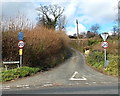
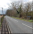
1

Junction of Pincot Lane and the A46 in Pitchcombe
Pincot Lane from the right joins the A46 Cheltenham Road.
Image: © Jaggery
Taken: 23 Mar 2014
0.01 miles
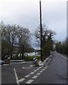
3
Wragg Castle Lane, Pitchcombe
Unsuitable for heavy goods vehicles and with a 20mph speed limit,
Wragg Castle Lane ascends towards the A4173 from the A46 Cheltenham Road.
Image: © Jaggery
Taken: 23 Mar 2014
0.03 miles
4
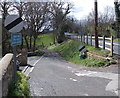
Pincot Lane, Pitchcombe
Unsuitable for heavy goods vehicles, Pincot Lane descends from the junction http://www.geograph.org.uk/photo/4062898 with the A46 Cheltenham Road.
Image: © Jaggery
Taken: 23 Mar 2014
0.04 miles
5

Houses in a valley near Painswick
Houses in Pincot Lane viewed from the A46 Cheltenham Road.
Image: © Jaggery
Taken: 23 Mar 2014
0.14 miles
6
NE boundary of Pitchcombe
The A46 Stroud Road passes the boundary sign for Pitchcombe,
a village in Gloucestershire, between Stroud and Painswick.
Image: © Jaggery
Taken: 23 Mar 2014
0.19 miles
7
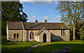
Sunday School, Pitchcombe
Dating from 1803, it pre-dates the present church by some 16 years. Extended and now in community use.
Image: © Philip Pankhurst
Taken: 21 May 2014
0.20 miles
8
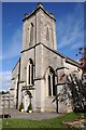
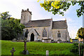
Pitchcombe church
The tower of St John the Baptist church, Pitchcombe. The church was built in 1819, replacing an earlier church.
Image: © Philip Halling
Taken: 11 Oct 2014
0.21 miles
9
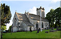
St John the Baptist, Pitchcombe
By William Franklin in 1819, on an older site.
Image: © Philip Pankhurst
Taken: 21 May 2014
0.21 miles