IMAGES TAKEN NEAR TO
Zion Hill, STROUD, GL6 6DB
Introduction
This page details the photographs taken nearby to Zion Hill, GL6 6DB by members of the Geograph project.
The Geograph project started in 2005 with the aim of publishing, organising and preserving representative images for every square kilometre of Great Britain, Ireland and the Isle of Man.

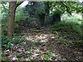
There are currently over 7.5m images from over14,400 individuals and you can help contribute to the project by visiting https://www.geograph.org.uk
Image Map
Images are licensed for reuse under creativecommons.org/licenses/by-sa/2.0
Notes
- Clicking on the map will re-center to the selected point.
- The higher the marker number, the further away the image location is from the centre of the postcode.
Image Listing (31 Images Found)
Images are licensed for reuse under creativecommons.org/licenses/by-sa/2.0
Image
Details
Distance
1
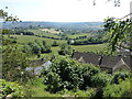
Looking down to Ruscombe
Cotswold landcapes often afford a fabulous view when descending from the heights and down into the valleys. Just down from this perch is The Close, part of the village of Ruscombe, which itself forms a crescent around the contours.
Image: © Neil Owen
Taken: 8 Jun 2023
0.02 miles
2
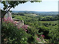
The view from Zion Hill
Ruscombe is a village that lines some of the steep Cotswold environment. Down below the Ruscombe Brook trickles away to the south.
Image: © Neil Owen
Taken: 8 Jun 2023
0.03 miles
3
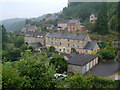
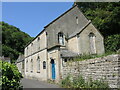
Ruscombe
Tucked into a narrow valley in the Cotswolds just north of Stroud. A view from the Congregational church.
Image: © Derek Harper
Taken: 5 Jul 2006
0.03 miles
4
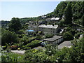
Rock Terrace from Ruscombe Road
Houses cling to the steep valley sides, with plenty of garden space though.
Image: © Neil Owen
Taken: 8 Jun 2023
0.03 miles
5
Ivy-covered Ruin
In woods near The Throat.
Image: © Mike White
Taken: 20 May 2009
0.07 miles
6
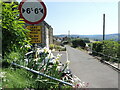
Lower Street - not for large vehicles
A twenty-first century sign alongside the circular plaque: the latter marks the creation of the Whiteshill and Ruscombe village Diamond Jubilee circular path.
Image: © Neil Owen
Taken: 8 Jun 2023
0.07 miles
7
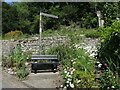
Resting at Ruscombe Road
A hairpin junction of Ruscombe Road and Lower Street provides a small patch of land which has been planted with many flowers and also has a bench seat. The seat affords a fabulous view over the valley below.
Image: © Neil Owen
Taken: 8 Jun 2023
0.07 miles
8
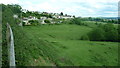
Fields towards Whiteshill from Ruscombe Road
Edge of Ruscombe Road reveals grassy fields looking towards Whiteshill. Horses visible in middle distance.
Image: © Clint Mann
Taken: 13 May 2011
0.07 miles
9
Ruscombe Road church
The little village clings to the twisty valley, with a church at the junction with The Throat. Outside is an old-fashioned blackboard.
Image: © Neil Owen
Taken: 8 Jun 2023
0.07 miles
10
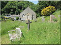
Resting in peace
Whether visiting or staying on a longer basis, Ruscombe church graveyard is a serene and tranquil place.
Image: © Neil Owen
Taken: 8 Jun 2023
0.08 miles