IMAGES TAKEN NEAR TO
Upper Kitesnest, STROUD, GL6 6BH
Introduction
This page details the photographs taken nearby to Upper Kitesnest, GL6 6BH by members of the Geograph project.
The Geograph project started in 2005 with the aim of publishing, organising and preserving representative images for every square kilometre of Great Britain, Ireland and the Isle of Man.

There are currently over 7.5m images from over14,400 individuals and you can help contribute to the project by visiting https://www.geograph.org.uk
Image Map
Images are licensed for reuse under creativecommons.org/licenses/by-sa/2.0
Notes
- Clicking on the map will re-center to the selected point.
- The higher the marker number, the further away the image location is from the centre of the postcode.
Image Listing (32 Images Found)
Images are licensed for reuse under creativecommons.org/licenses/by-sa/2.0
Image
Details
Distance
1

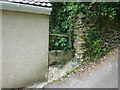
Stone Stile, Whiteshill
A fallen idle, right at the point where Gloucestershire footpath MWH3 emerges onto the farm track at the end of Lower Kitesnest Lane. A remnant of what was presumably a squeeze stile.
Image: © Mr Red
Taken: 9 Jan 2022
0.08 miles
2
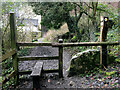
Stone Stile, Ruscombe
At the rear of a house in "The Throat", Ruscombe. This would have been simple access to the back of the house.
Image: © Mr Red
Taken: 15 Jul 2022
0.14 miles
3
Stone Stile, Shermans Cottage, Sherman's Wood GS9314
Stone stile (remains of possible slab or squeeze) near Shermans Cottage at entrance to Sherman's Wood. At end of footpath running from Kitesnest Farm, Whiteshill. Now a wooden stile. At parish boundary, junction of public right of way MWH3 and MPC12 (wood).
Image: © Maggie Booth
Taken: 1 Feb 2021
0.15 miles
4
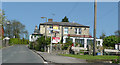
The Woodcutter's Arms, Whiteshill
Presumably an important local industry in times gone by.
Image: © Jonathan Billinger
Taken: 6 May 2008
0.15 miles
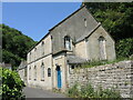
5
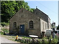
Ruscombe school room
The building beside the church is the old school hall, built in 1825 and rebuilt in 1934. The rooms are now a community venue.
Image: © Neil Owen
Taken: 8 Jun 2023
0.17 miles
6
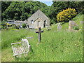
Resting in peace
Whether visiting or staying on a longer basis, Ruscombe church graveyard is a serene and tranquil place.
Image: © Neil Owen
Taken: 8 Jun 2023
0.17 miles
7
Ruscombe Road church
The little village clings to the twisty valley, with a church at the junction with The Throat. Outside is an old-fashioned blackboard.
Image: © Neil Owen
Taken: 8 Jun 2023
0.17 miles
8

Between The Mount and The Throat
Some of the typical Cotswold landscaping around Whiteshill has a rich carpet of wildflowers and the valleys are mottled by trees.
Image: © Neil Owen
Taken: 8 Jun 2023
0.17 miles
9
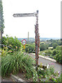
Fingerpost, Ruscombe, Stroud
At the acute junction of Ruscombe Road and Lower Street, by "the Throat". Old style post with castellated sleeves holding a wooden finger.
Inscription: Whiteshill / Stroud // blank/weathered
Milestone Society National ID: GL_SO8307
Image: © Mr Red
Taken: 15 Jul 2022
0.18 miles
10
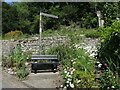
Resting at Ruscombe Road
A hairpin junction of Ruscombe Road and Lower Street provides a small patch of land which has been planted with many flowers and also has a bench seat. The seat affords a fabulous view over the valley below.
Image: © Neil Owen
Taken: 8 Jun 2023
0.18 miles