IMAGES TAKEN NEAR TO
Shortwood, STROUD, GL6 0SN
Introduction
This page details the photographs taken nearby to Shortwood, GL6 0SN by members of the Geograph project.
The Geograph project started in 2005 with the aim of publishing, organising and preserving representative images for every square kilometre of Great Britain, Ireland and the Isle of Man.

There are currently over 7.5m images from over14,400 individuals and you can help contribute to the project by visiting https://www.geograph.org.uk
Image Map
Images are licensed for reuse under creativecommons.org/licenses/by-sa/2.0
Notes
- Clicking on the map will re-center to the selected point.
- The higher the marker number, the further away the image location is from the centre of the postcode.
Image Listing (10 Images Found)
Images are licensed for reuse under creativecommons.org/licenses/by-sa/2.0
Image
Details
Distance
1
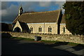
Shortwood Church
All Saints church at Shortwood was built in 1865.
Image: © Philip Halling
Taken: 6 Nov 2010
0.06 miles
2
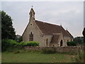
All Saints Church
All Saints church is in Shortwood on the outskirts of Nailsworth. It was completed in 1866, but its simple style is much earlier.
Image: © Sharon Loxton
Taken: 28 Jun 2006
0.09 miles
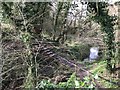
3

Boundary Stone, Shortwood, Nailsworth
This concrete post is one of 5 on a section of land with Gloucestershire footpaths MHO10 & MHO12 at the apex . It is probably designated as part of the highway. It marks the boundary between Nailsworth town and Horsley parish. It was moved to its current field boundary position from the line of the road in 1935. Similar posts are http://www.geograph.org.uk/photo/7070608 & http://www.geograph.org.uk/photo/7070604 & http://www.geograph.org.uk/photo/7070601 & http://www.geograph.org.uk/photo/7070598
Milestone Society National ID: GL_HORNAI01pb
Image: © Mr Red
Taken: 14 Jan 2022
0.10 miles
4

Boundary Stone, Shortwood, Nailsworth
This concrete post is one of 5 on a section of land with Gloucestershire footpaths MHO10 & MHO12 at the apex . It is probably designated as part of the highway. It marks the boundary between Nailsworth town and Horsley parish. It was moved to its current field boundary position from the line of the road in 1935. Similar posts are http://www.geograph.org.uk/photo/7070612 & http://www.geograph.org.uk/photo/7070604 & http://www.geograph.org.uk/photo/7070601 & http://www.geograph.org.uk/photo/7070598
Milestone Society National ID: GL_HORNAI02pb
Image: © Mr Red
Taken: 14 Jan 2022
0.10 miles
5

Boundary Stone, Shortwood, Nailsworth
This concrete post is one of 5 on a section of land with Gloucestershire footpaths MHO10 & MHO12 at the apex . It is probably designated as part of the highway. It marks the boundary between Nailsworth town and Horsley parish. It was moved to its current field boundary position from the line of the road in 1935. Similar posts are http://www.geograph.org.uk/photo/7070612 & http://www.geograph.org.uk/photo/7070608 & http://www.geograph.org.uk/photo/7070601 & http://www.geograph.org.uk/photo/7070598
Milestone Society National ID: GL_HORNAI03pb
Image: © Mr Red
Taken: 14 Jan 2022
0.11 miles
6

Boundary Stone, Shortwood, Nailsworth
This concrete post is one of 5 on a section of land with Gloucestershire footpaths MHO10 & MHO12 at the apex . It is probably designated as part of the highway. It marks the boundary between Nailsworth town and Horsley parish. It was moved to its current field boundary position from the line of the road in 1935. Similar posts are http://www.geograph.org.uk/photo/7070612 & http://www.geograph.org.uk/photo/7070608 & http://www.geograph.org.uk/photo/7070604 & http://www.geograph.org.uk/photo/7070598
Milestone Society National ID: GL_HORNAI04pb
Image: © Mr Red
Taken: 14 Jan 2022
0.11 miles
7

Boundary Stone, Shortwood, Nailsworth
This concrete post is one of 5 on a section of land with Gloucestershire footpaths MHO10 & MHO12 at the apex . It is probably designated as part of the highway. It marks the boundary between Nailsworth town and Horsley parish. It was moved to its current field boundary position from the line of the road in 1935. Similar posts are http://www.geograph.org.uk/photo/7070612 & http://www.geograph.org.uk/photo/7070608 & http://www.geograph.org.uk/photo/7070604 & http://www.geograph.org.uk/photo/7070601
Milestone Society National ID: GL_HORNAI05pb
Image: © Mr Red
Taken: 14 Jan 2022
0.11 miles
9
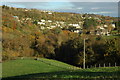
Valley above Nailsworth
Houses in a valley above Nailsworth pictured from a track west of Lower Lutheridge Farm.
Image: © Philip Halling
Taken: 6 Nov 2010
0.17 miles
10
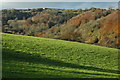
View to High Wood
View across a valley to High Wood to the west of Nailsworth.
Image: © Philip Halling
Taken: 6 Nov 2010
0.21 miles