IMAGES TAKEN NEAR TO
Ragnal Lane, STROUD, GL6 0RU
Introduction
This page details the photographs taken nearby to Ragnal Lane, GL6 0RU by members of the Geograph project.
The Geograph project started in 2005 with the aim of publishing, organising and preserving representative images for every square kilometre of Great Britain, Ireland and the Isle of Man.

There are currently over 7.5m images from over14,400 individuals and you can help contribute to the project by visiting https://www.geograph.org.uk
Image Map
Images are licensed for reuse under creativecommons.org/licenses/by-sa/2.0
Notes
- Clicking on the map will re-center to the selected point.
- The higher the marker number, the further away the image location is from the centre of the postcode.
Image Listing (22 Images Found)
Images are licensed for reuse under creativecommons.org/licenses/by-sa/2.0
Image
Details
Distance
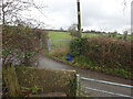
1
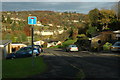
Road in Shortwood
Residential road above Nailsworth.
Image: © Philip Halling
Taken: 6 Nov 2010
0.08 miles
2
Stone Stile, Nailsworth
Private "gap in the wall" stile off Gloucestershire footpath ZNA18. There is a door to a subsequently built shed coincident with it, obviously intended as an emergency exit.
Image: © Mr Red
Taken: 11 Jan 2022
0.08 miles
3

Stone Stile, Nailsworth
In the Newmarket area of Nailsworth, next to the Nailsworth Donkey Sanctuary. At the exit of Gloucestershire footpath ZNA16 onto Newmarket Road.
Image: © Mr Red
Taken: 14 Jan 2022
0.10 miles
4

Stone Stile, Nailsworth
Concrete squeeze stile up steps from Walkley Lane on Gloucestershire footpath ZNA20 looking NE to the lane. The view SW is Image
Image: © Mr Red
Taken: 14 Jan 2022
0.10 miles
5

Stone Stile, Nailsworth
Concrete squeeze stile up steps from Walkley Lane on Gloucestershire footpath ZNA20 looking SW. The view NE toward the road is Image
Image: © Mr Red
Taken: 14 Jan 2022
0.10 miles
6
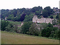
New development in Worley
A row of new houses, built in the traditional Cotswold stone, in the Worley area of Nailsworth. The view is across a deep valley which carries Miry Brook.
Image: © Sharon Loxton
Taken: 28 Jun 2006
0.13 miles
7
Worley, Nailsworth
Nailsworth lies at the confluence of several valleys. This view is across the valley leading in from the west. The houses on the far side probably date from the 1960s or 70s.
Image: © Brian Robert Marshall
Taken: 11 Nov 2008
0.14 miles
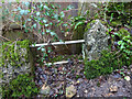
8
Stone Stile, Nailsworth
To the North of "Cleves" on Gloucestershire footpath ZNA20. The view from the road is Image
Image: © Mr Red
Taken: 11 Jan 2022
0.15 miles
9

Stone Stile, Nailsworth
To the North of "Cleves" on Gloucestershire footpath ZNA20. The view from the field is Image
Image: © Mr Red
Taken: 11 Jan 2022
0.15 miles
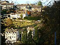
10
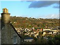
Nailsworth from Rockness
The centre of the town is seen from near Rockness House (the property at the left), which occupies a position on the western side of the valley in which the town is situated.
Image: © Brian Robert Marshall
Taken: 11 Nov 2008
0.19 miles