IMAGES TAKEN NEAR TO
Draycott, MORETON-IN-MARSH, GL56 9LE
Introduction
This page details the photographs taken nearby to GL56 9LE by members of the Geograph project.
The Geograph project started in 2005 with the aim of publishing, organising and preserving representative images for every square kilometre of Great Britain, Ireland and the Isle of Man.

There are currently over 7.5m images from over14,400 individuals and you can help contribute to the project by visiting https://www.geograph.org.uk
Image Map
Images are licensed for reuse under creativecommons.org/licenses/by-sa/2.0
Notes
- Clicking on the map will re-center to the selected point.
- The higher the marker number, the further away the image location is from the centre of the postcode.
Image Listing (9 Images Found)
Images are licensed for reuse under creativecommons.org/licenses/by-sa/2.0
Image
Details
Distance
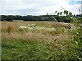
2
View NNE near Lynch Coppice
Looking NNE from the lane that runs from Draycott towards Batsford.
Image: © David P Howard
Taken: 27 Oct 2010
0.12 miles
3
Lynch Coppice near Draycott
The field in front of the coppice has a pronounced ridge and furrow system, highlighted by the low angle of the sun.
Image: © David P Howard
Taken: 27 Oct 2010
0.18 miles
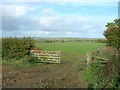
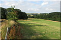
5
Farmland at Draycott
Difficult to identify the crop being grown here in this field on the edge of the village of Drayton.
Image: © Philip Halling
Taken: 16 Jul 2016
0.22 miles
6
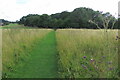
View from a stile, of footpath and woods beyond
Image: © Philip Jeffrey
Taken: 1 Aug 2021
0.23 miles
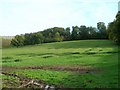
7
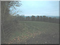
Draycott farmland
North Cotswolds farmland near to Draycott village.
Image: © Dennis Turner
Taken: 12 Feb 2006
0.24 miles
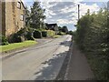
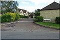
9
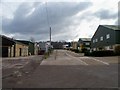
Draycott Industrial Estate
Seen from the minor road.
Image: © Michael Dibb
Taken: 13 Feb 2010
0.25 miles