IMAGES TAKEN NEAR TO
Pasture Lane, MORETON-IN-MARSH, GL56 9DR
Introduction
This page details the photographs taken nearby to Pasture Lane, GL56 9DR by members of the Geograph project.
The Geograph project started in 2005 with the aim of publishing, organising and preserving representative images for every square kilometre of Great Britain, Ireland and the Isle of Man.

There are currently over 7.5m images from over14,400 individuals and you can help contribute to the project by visiting https://www.geograph.org.uk
Image Map
Images are licensed for reuse under creativecommons.org/licenses/by-sa/2.0
Notes
- Clicking on the map will re-center to the selected point.
- The higher the marker number, the further away the image location is from the centre of the postcode.
Image Listing (108 Images Found)
Images are licensed for reuse under creativecommons.org/licenses/by-sa/2.0
Image
Details
Distance
1
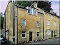
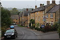
Pear Tree Cottage
This cottage is on the west side of Lower Street and a hundred years ago used to be the "Pear Tree Inn".
Image: © Anthony Harrison
Taken: 5 Jul 2009
0.06 miles
2
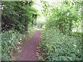
Newly created footpath
This footpath has been recently created, complete with rubber matting underfoot, to allow walkers to avoid the busy B4479 road for a short stretch. The path forms part of three combined long distance paths - the Heart of England Way, the Monarch's Way and the Diamond Way.
Image: © Michael Dibb
Taken: 9 Jun 2010
0.09 miles
3

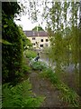
Broad Bodied Chaser (Libullela depressa) , Mill Dene Gardens, Blockley
This photograph was taken close to the mill pond. It is either a female or an immature male. Adult males are sky blue.
Image: © Graham Taylor
Taken: 23 May 2008
0.09 miles
4
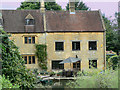
Mill Dene Gardens, Blockley
This is a view looking down the mill pond to the mill house. The bird in the centre is not a new species - it's made of bronze. During heavy rain in the summer of 2007 the mill was badly flooded and part of the gardens washed away. The owners had made a terrific effort to mend the damage, and when this photograph was taken there were absolutely no signs that there had ever been anything wrong. There is a book of pictures of the flood damage in the excellent tea room.
Image: © Graham Taylor
Taken: 23 May 2008
0.09 miles
5
Milldene
The part of the building on the right was known as Blockley Mill. After the silk trade ceased, the building was used as a forge making piano frames, and subsequently it was renamed Vulcan Forge and forged other item such as drain gratings. The original building was only two-thirds the height, but was burnt down in the mid-1920s and was rebuilt to the same height as the attached house, which is now known as Milldene.
Image: © Anthony Harrison
Taken: 5 Jul 2009
0.10 miles
6
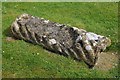
Bale tomb, Blockley churchyard
Bale tombs are quite common in the graveyards of Cotswold churches, reflecting the wealth created by the wool trade, this one is at Blockley.
Image: © Philip Halling
Taken: 9 May 2015
0.10 miles
8
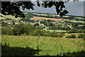
Blockley viewed from the south-east
Blockley viewed from the Monarch's Way and Heart of England Way. The large church dedicated to St Peter and St Paul can be seen in the centre.
Image: © Philip Halling
Taken: 19 Jul 2008
0.10 miles
9
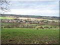
A view of Blockley
The combined Heart of England Way and Monarch's Way long distance path has descended very gently from the minor road but where it joins another path, the gradient steepens appreciably. A footpath running along a track flanked with some magnificent trees runs along the contour and affords some wonderful views. This is the view of Blockley.
Image: © Michael Dibb
Taken: 16 Nov 2009
0.11 miles
10
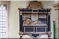
Church of St Peter & St Paul, Blockley: monument to Anne Childe
An unusual monument with the reclining marble effigy of Ann Mary Childe (†1659) on a tomb-chest.
Image: © Mike Searle
Taken: 10 Apr 2014
0.11 miles