IMAGES TAKEN NEAR TO
Rooksmoor, STROUD, GL5 5NB
Introduction
This page details the photographs taken nearby to Rooksmoor, GL5 5NB by members of the Geograph project.
The Geograph project started in 2005 with the aim of publishing, organising and preserving representative images for every square kilometre of Great Britain, Ireland and the Isle of Man.

There are currently over 7.5m images from over14,400 individuals and you can help contribute to the project by visiting https://www.geograph.org.uk
Image Map (Loading...)


Getting Data...Please wait
Leaflet Map data © OpenStreetMap
Images are licensed for reuse under creativecommons.org/licenses/by-sa/2.0
Notes
- Clicking on the map will re-center to the selected point.
- The higher the marker number, the further away the image location is from the centre of the postcode.
Image Listing (68 Images Found)
Images are licensed for reuse under creativecommons.org/licenses/by-sa/2.0
Image
Details
Distance
1
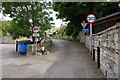
Bottom of Rooksmoor Hill, Rooksmoor
Viewed across the A46 Bath Road about midway between Stroud and Nailsworth.
Signs alongside Rooksmoor Hill show a 30mph speed limit ahead, unsuitable for heavy goods vehicles
and no vehicles heavier than 7.5 tonnes (except for loading).
Image: © Jaggery
Taken: 18 Oct 2015
0.02 miles
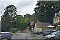
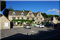
5
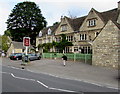
Old Fleece, Rooksmoor
Originally a coaching inn, the Old Fleece is a pub and restaurant on the east side of the A46 Bath Road, midway between Stroud and Nailsworth. The name Old Fleece is a reminder of the wool industry which created great wealth in the Gloucestershire Cotswolds.
Image: © Jaggery
Taken: 18 Oct 2015
0.03 miles
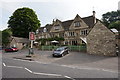
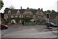
7
The Old Fleece, Rooksmoor
Quite a large but pleasant pub on the A46.
Image: © Bill Boaden
Taken: 17 Jul 2016
0.04 miles

9
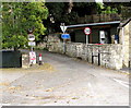
Rooksmoor Mill electricity substation, Rooksmoor
Located on the west side of the A46 Bath Road, near this entrance. http://www.geograph.org.uk/photo/4708062
The Western Power Distribution electricity substation identifier is ROOKSMOOR MILL 9510.
A Caution label shows the presence of SF6 (sulphur hexafluoride, an insulating gas used in high voltage systems). A Thieves Beware notice states that Smartwater Forensic Trap Devices are in use. Police and scrap dealers are checking for Smartwater. Cable and metal is traceable. Thieves can be tracked. 100% conviction rate.
Image: © Jaggery
Taken: 18 Oct 2015
0.04 miles
10
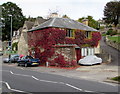
Ivy-clad building in Rooksmoor
Ivy in its autumn colours, viewed across the A46 Bath Road in mid October 2015.
Image: © Jaggery
Taken: 18 Oct 2015
0.05 miles