IMAGES TAKEN NEAR TO
Inchbrook, STROUD, GL5 5HA
Introduction
This page details the photographs taken nearby to GL5 5HA by members of the Geograph project.
The Geograph project started in 2005 with the aim of publishing, organising and preserving representative images for every square kilometre of Great Britain, Ireland and the Isle of Man.

There are currently over 7.5m images from over14,400 individuals and you can help contribute to the project by visiting https://www.geograph.org.uk
Image Map
Images are licensed for reuse under creativecommons.org/licenses/by-sa/2.0
Notes
- Clicking on the map will re-center to the selected point.
- The higher the marker number, the further away the image location is from the centre of the postcode.
Image Listing (85 Images Found)
Images are licensed for reuse under creativecommons.org/licenses/by-sa/2.0
Image
Details
Distance
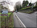
1
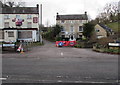
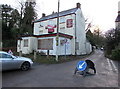
Valley Road, Inchbrook
Viewed across the A46. The name signs show that Valley Road is not a through route.
It leads to Cow Lane, Inchbrook Way and Millbrook Walk. The derelict former Crown Inn is on the left.
Image: © Jaggery
Taken: 20 Dec 2015
0.06 miles
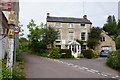
3
The Laurels At Inchbrook
Guesthouse in Cow Lane, Inchbrook, 35 metres west of the A46 Bath Road between Stroud and Nailsworth.
Image: © Jaggery
Taken: 20 Dec 2015
0.07 miles
4
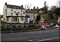
Boarded-up former pub, Inchbrook
On December 20th 2015, a SOLD label is on the For Sale board on the derelict former Crown Inn,
viewed across the A46 near Nailsworth. Temporary triangular signs warn of roadworks around the corner.
Image: © Jaggery
Taken: 20 Dec 2015
0.07 miles
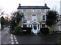
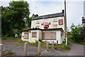
6
Former Crown Inn, Inchbrook
On December 20th 2015, a SOLD label is on the For Sale board on the derelict
building on the corner of Valley Road and the A46, between Stroud and Nailsworth.
Image: © Jaggery
Taken: 20 Dec 2015
0.07 miles
8
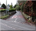
Inchbrook Hill, Nailsworth
Ascending from the A46 Stroud Road at the northern edge of Nailsworth. Signs show the start of a 20mph speed limit and an unsuitable route for heavy goods vehicles. Vehicle width limit 6' 6".
Image: © Jaggery
Taken: 20 Dec 2015
0.08 miles
9
Northern boundary of Nailsworth
The A46 from Stroud reaches Nailsworth. The Inchbrook Hill http://www.geograph.org.uk/photo/4777481 junction is on the right.
Nailsworth, a Fair Trade Town in Gloucestershire, is twinned with Leves (France).
Image: © Jaggery
Taken: 20 Dec 2015
0.09 miles
10
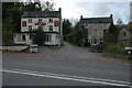
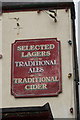
The Crown Inn, Nailsworth
Situated beside the A46, the Crown Inn now appears to be closed.
Image: © Philip Halling
Taken: 8 Nov 2008
0.09 miles