IMAGES TAKEN NEAR TO
High Street, STROUD, GL5 5EL
Introduction
This page details the photographs taken nearby to High Street, GL5 5EL by members of the Geograph project.
The Geograph project started in 2005 with the aim of publishing, organising and preserving representative images for every square kilometre of Great Britain, Ireland and the Isle of Man.

There are currently over 7.5m images from over14,400 individuals and you can help contribute to the project by visiting https://www.geograph.org.uk
Image Map
Images are licensed for reuse under creativecommons.org/licenses/by-sa/2.0
Notes
- Clicking on the map will re-center to the selected point.
- The higher the marker number, the further away the image location is from the centre of the postcode.
Image Listing (46 Images Found)
Images are licensed for reuse under creativecommons.org/licenses/by-sa/2.0
Image
Details
Distance
1
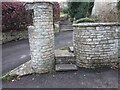
Modern Stone Stile, Woodchester
Laggar Lane, South Woodchester, at the private entrance to Field House. A little further NW, Laggar Lane is designated Gloucestershire footpath MWO11.
Image: © Mr Red
Taken: 9 Jan 2022
0.11 miles
2
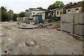
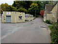
Industrial yard, Woodchester
On the south side of Station Road, alongside Nailsworth Stream.
The yard's location suggests that this may have been the railway
yard near the long since demolished Woodchester railway station.
Image: © Jaggery
Taken: 18 Oct 2015
0.13 miles
3
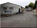
Woodchester Self Storage Units, Woodchester
Located in Station Road Industrial Estate.
Image: © Jaggery
Taken: 18 Oct 2015
0.13 miles
4
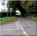
Narrow streets sign, Woodchester
On the corner of High Street and Station Road, a blue sign states that narrow streets ahead are unsuitable for heavy/wide vehicles. Another sign directs heavy goods vehicles left onto Station Road for the A46 Bath Road, avoiding the village.
Image: © Jaggery
Taken: 18 Oct 2015
0.14 miles
5
Click Property Services in Woodchester
Located in Unit A, Station Road Industrial Estate, Woodchester.
Image: © Jaggery
Taken: 18 Oct 2015
0.14 miles
6
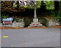
Woodchester War Memorial
The Celtic cross on a stepped base is set back from the junction of Station Road, High Street and Southfield Road, between South Woodchester and North Woodchester.
Image: © Jaggery
Taken: 18 Oct 2015
0.14 miles
7
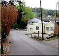
Station Road Woodchester
Station Road descends towards the A46 Bath Road past Station Road Industrial Estate.
Image: © Jaggery
Taken: 18 Oct 2015
0.14 miles
8
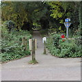
Cycleway and footpath from Woodchester towards Nailsworth
Now part of National Cycle Network route 45, this route south alongside Nailsworth Stream uses the trackbed of a dismantled railway.
Image: © Jaggery
Taken: 18 Oct 2015
0.14 miles
9
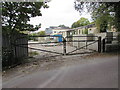
Yard entrance gates, Woodchester
From Station Road to this http://www.geograph.org.uk/photo/4732817 yard.
Image: © Jaggery
Taken: 18 Oct 2015
0.15 miles
10
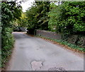
Road bridge over Nailsworth Stream, Woodchester
On the approach to the A46 Bath Road, Station Road crosses the bridge over Nailsworth Stream.
Image: © Jaggery
Taken: 18 Oct 2015
0.15 miles