IMAGES TAKEN NEAR TO
The Street, STROUD, GL5 5DP
Introduction
This page details the photographs taken nearby to The Street, GL5 5DP by members of the Geograph project.
The Geograph project started in 2005 with the aim of publishing, organising and preserving representative images for every square kilometre of Great Britain, Ireland and the Isle of Man.

There are currently over 7.5m images from over14,400 individuals and you can help contribute to the project by visiting https://www.geograph.org.uk
Image Map
Images are licensed for reuse under creativecommons.org/licenses/by-sa/2.0
Notes
- Clicking on the map will re-center to the selected point.
- The higher the marker number, the further away the image location is from the centre of the postcode.
Image Listing (18 Images Found)
Images are licensed for reuse under creativecommons.org/licenses/by-sa/2.0
Image
Details
Distance
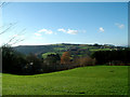
1
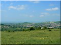
A view from Rodborough Common
Looking towards the south-west, the village in the valley is Woodchester. On the left horizon is the Nympsfield wind turbine in SO8100.
Image: © Brian Robert Marshall
Taken: 14 May 2008
0.08 miles
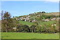
2
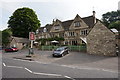
Little London
Small hamlet just outside Kingscourt at the foot of Rodborough Common.
Image: © Angus Townley
Taken: 16 Jul 2005
0.08 miles
3
Selsley Common from Rodborough
Taken from somewhat undulating Gastrells School playing fields looking due west. This ridge is very popular with paragliders, hang-gliders, gliders and model gliders, can get a bit busy up there!
Image: © Richard Haworth
Taken: 4 May 2005
0.14 miles
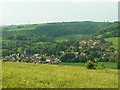
4
View from Woodchester
Looking east towards Stroud.
Image: © Wayland Smith
Taken: 6 May 2013
0.14 miles
5
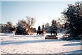
Rodborough Common, near Stroud
Looking south, towards the enclosed housing estate at the top of the Common.
Image: © Alex Cameron
Taken: 19 Dec 1999
0.16 miles
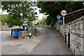
6
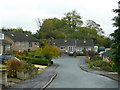
Birch Road, Kingscourt
A suburban cul-de-sac set high above the floor of the Nailsworth Valley to the south of Stroud.
Image: © Jonathan Billinger
Taken: 5 Nov 2008
0.19 miles
7
A view from Rodborough Common
This is looking to the north-west. On the far horizon is the Forest of Dean part of Gloucestershire just above the River Severn. The hill in the middle is, I think, Doverow Hill, just east of Stonehouse.
Image: © Brian Robert Marshall
Taken: 14 May 2008
0.22 miles
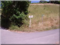
8
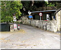
Bottom of Rooksmoor Hill, Rooksmoor
Viewed across the A46 Bath Road about midway between Stroud and Nailsworth.
Signs alongside Rooksmoor Hill show a 30mph speed limit ahead, unsuitable for heavy goods vehicles
and no vehicles heavier than 7.5 tonnes (except for loading).
Image: © Jaggery
Taken: 18 Oct 2015
0.23 miles