IMAGES TAKEN NEAR TO
Stratford Road, CHIPPING CAMPDEN, GL55 6SW
Introduction
This page details the photographs taken nearby to Stratford Road, GL55 6SW by members of the Geograph project.
The Geograph project started in 2005 with the aim of publishing, organising and preserving representative images for every square kilometre of Great Britain, Ireland and the Isle of Man.

There are currently over 7.5m images from over14,400 individuals and you can help contribute to the project by visiting https://www.geograph.org.uk
Image Map
Images are licensed for reuse under creativecommons.org/licenses/by-sa/2.0
Notes
- Clicking on the map will re-center to the selected point.
- The higher the marker number, the further away the image location is from the centre of the postcode.
Image Listing (24 Images Found)
Images are licensed for reuse under creativecommons.org/licenses/by-sa/2.0
Image
Details
Distance
1
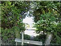
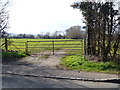
Through the hedge
After crossing the field, the footpath, part of the Heart of England Way, passes through the hedge the other side of which is the B4632 Stratford Road.
Image: © Michael Dibb
Taken: 23 Apr 2011
0.02 miles
2
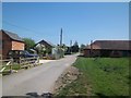
Down the lane
The Heart of England Way, after crossing the B4632 Stratford Road, passes along Canada Lane.
Image: © Michael Dibb
Taken: 23 Apr 2011
0.02 miles
3
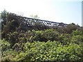
Meon Hill Nurseries
An odd pane of glass remains in the derelict glasshouses of what was once Meon Hill Nurseries. There are some 25 large glasshouses now all sadly overgrown and derelict. Seen from Canada Lane which is part of the Heart of England Way.
Image: © Michael Dibb
Taken: 23 Apr 2011
0.06 miles
4
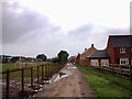
Canada Lane, Mickleton
The Shepherd's Fold new homes development by CALA Homes is on the right
Image: © Tim Heaton
Taken: 25 Sep 2017
0.07 miles
5
Path leaves the road
From Stratford Road, the footpath crosses the field towards the centre of Mickleton village.
Image: © Michael Dibb
Taken: 10 Mar 2012
0.09 miles
6
![Two ways to go [2]](https://s2.geograph.org.uk/geophotos/02/39/06/2390638_78144bf2_120x120.jpg)
Two ways to go [2]
At the edge of the playing field, the path makes a 'T' junction. To the right, this path, part of the Heart of England Way runs across the field towards the B4632 road.
Image: © Michael Dibb
Taken: 23 Apr 2011
0.09 miles
7
![Allotment gardens [2]](https://s1.geograph.org.uk/geophotos/02/93/74/2937405_f7096238_120x120.jpg)
Allotment gardens [2]
The gardens are owned by Mickleton Poor's Land Trust, a registered charity and founded in 1612.
Image: © Michael Dibb
Taken: 10 Mar 2012
0.10 miles
8
![Allotment gardens [1]](https://s1.geograph.org.uk/geophotos/02/93/73/2937393_413f169a_120x120.jpg)
Allotment gardens [1]
These allotments belong to Mickleton Poor's Land Trust and are alongside Stratford Road.
Image: © Michael Dibb
Taken: 10 Mar 2012
0.13 miles
9
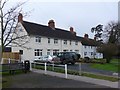
Granbrook Lane Mickleton
These terraced houses are on the northern edge of the grid square in the centre of the village.
Image: © Nigel Mykura
Taken: 20 Feb 2011
0.14 miles
10
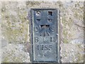
Ordnance Survey Flush Bracket 1755
This bracket can be found on the roadside wall of a dwelling in Mickleton. The benchmark height is recorded as being 72.655 metres above sea level. For more detail see : http://www.bench-marks.org.uk/bm10268
Image: © Peter Wood
Taken: 6 Nov 2017
0.14 miles