IMAGES TAKEN NEAR TO
Aston Sub Edge, CHIPPING CAMPDEN, GL55 6PY
Introduction
This page details the photographs taken nearby to GL55 6PY by members of the Geograph project.
The Geograph project started in 2005 with the aim of publishing, organising and preserving representative images for every square kilometre of Great Britain, Ireland and the Isle of Man.

There are currently over 7.5m images from over14,400 individuals and you can help contribute to the project by visiting https://www.geograph.org.uk
Image Map
Images are licensed for reuse under creativecommons.org/licenses/by-sa/2.0
Notes
- Clicking on the map will re-center to the selected point.
- The higher the marker number, the further away the image location is from the centre of the postcode.
Image Listing (16 Images Found)
Images are licensed for reuse under creativecommons.org/licenses/by-sa/2.0
Image
Details
Distance
1
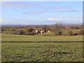
Norton Grounds Farm
View west from the bridleway to Norton Hall from near its junction with the B4632.
Image: © David P Howard
Taken: 17 Dec 2011
0.04 miles
2
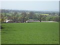
Norton Grounds Farm
Seen from the bridleway are the roofs of Norton Grounds Farm tucked just over the ridge of Thistley Hill.
Image: © Michael Dibb
Taken: 10 Apr 2011
0.05 miles
3
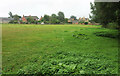
Norton Grounds Farm
Seen from Weston-sub-Edge footpath 5#3 - or possibly 5#2. The farmhouse, on the right, is listed https://historicengland.org.uk/listing/the-list/list-entry/1088510?section=official-list-entry .
Image: © Derek Harper
Taken: 14 Sep 2021
0.05 miles
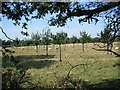
4
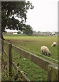
Sheep, Norton Grounds Farm
Looking left from Image So poor is the light, I nearly made this monochrome.
Image: © Derek Harper
Taken: 14 Sep 2021
0.12 miles
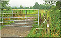
5
Stile near Norton Grounds Farm
One of a succession of stiles on Weston-sub-Edge footpath 5#3.
Image: © Derek Harper
Taken: 14 Sep 2021
0.13 miles
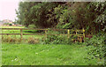
6
Gate near Norton Grounds Farm
Across a footpath which immediately crosses a parish boundary in the form of a stream to become Aston Subedge footpath 2, though this isn't where or how the path and its junction are shown on maps.
Image: © Derek Harper
Taken: 14 Sep 2021
0.14 miles
7
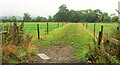
Footpath near Norton Grounds Farm
From the gate show in Image], a clearer view along Aston Subedge footpath 2.
Image: © Derek Harper
Taken: 14 Sep 2021
0.15 miles
8
![Branch path [1]](https://s1.geograph.org.uk/geophotos/02/51/27/2512773_bf97cd95_120x120.jpg)
Branch path [1]
Another footpath branches off and, after crossing the stream, heads towards Norton Grounds Farm, seen in the distance.
Image: © Michael Dibb
Taken: 19 Jun 2011
0.16 miles
9
![Paths cross [3]](https://s0.geograph.org.uk/geophotos/02/51/27/2512748_282693e0_120x120.jpg)
Paths cross [3]
Two footpaths cross at this point. This path follows the field edge towards Norton Grounds Farm (seen in the distance) and on to The Dingle.
Image: © Michael Dibb
Taken: 19 Jun 2011
0.17 miles
10
Orchard at Aston-sub-Edge
Orchard of young trees and sheep of an indeterminate age, looking north-west from the Aston-sub-Edge to Mickleton road.
Image: © Dave Bushell
Taken: 12 Sep 2005
0.20 miles