IMAGES TAKEN NEAR TO
Poplars Close, CHIPPING CAMPDEN, GL55 6EN
Introduction
This page details the photographs taken nearby to Poplars Close, GL55 6EN by members of the Geograph project.
The Geograph project started in 2005 with the aim of publishing, organising and preserving representative images for every square kilometre of Great Britain, Ireland and the Isle of Man.

There are currently over 7.5m images from over14,400 individuals and you can help contribute to the project by visiting https://www.geograph.org.uk
Image Map
Images are licensed for reuse under creativecommons.org/licenses/by-sa/2.0
Notes
- Clicking on the map will re-center to the selected point.
- The higher the marker number, the further away the image location is from the centre of the postcode.
Image Listing (40 Images Found)
Images are licensed for reuse under creativecommons.org/licenses/by-sa/2.0
Image
Details
Distance
2
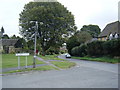
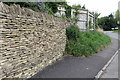
Blind Lane in Westington joining B4018
Looking south-eastward.
Image: © Peter Wood
Taken: 6 Nov 2017
0.03 miles
3
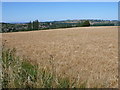
Chipping Campden
View across a ripening field of wheat just off Conduit Hill. The town can be seen in the background.
Image: © Nigel Mykura
Taken: 24 Jul 2011
0.04 miles
4
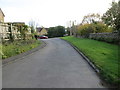
Conduit Hill
The B4088 road runs from the A44 at Cross Hands through Chipping Campden to Mickleton. Here, as it descends into Chipping Campden, it is known as Conduit Hill. The road to the right is Blind Lane.
Image: © Michael Dibb
Taken: 17 Jun 2010
0.04 miles
5

Thatched cottage
In the Westington area of Chipping Campden. Taken on the weekend they have their gardens open for charity.
Image: © John Smith
Taken: 18 Jun 2005
0.04 miles
6
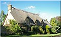
Cotswold stone, thatched house
On the left as you enter Chipping Campden down Conduit Hill.
Image: © Jennifer Luther Thomas
Taken: 7 Sep 2006
0.04 miles
8
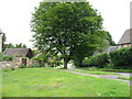
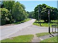
The approach to Chipping Campden
This is the B4081, just as it enters the town after descending Conduit Hill.
Image: © David Purchase
Taken: 18 Jun 2013
0.05 miles
9
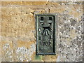
Ordnance Survey Flush Bracket 1762
This bracket can be found on the roadside wall of a building in Blind Lane, Westington. The benchmark height is recorded as being 155.095 metres above sea level. For more detail see : http://www.bench-marks.org.uk/bm10275
Image: © Peter Wood
Taken: 6 Nov 2017
0.06 miles
10
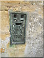
Ordnance Survey Flush Bracket (1762)
This OS Flush Bracket can be found on the SW face of a barn at Westington. It marks a point 155.0902m above mean sea level.
Image: © Adrian Dust
Taken: 27 Jun 2015
0.06 miles