IMAGES TAKEN NEAR TO
Malvern Gardens, STROUD, GL5 4LR
Introduction
This page details the photographs taken nearby to Malvern Gardens, GL5 4LR by members of the Geograph project.
The Geograph project started in 2005 with the aim of publishing, organising and preserving representative images for every square kilometre of Great Britain, Ireland and the Isle of Man.

There are currently over 7.5m images from over14,400 individuals and you can help contribute to the project by visiting https://www.geograph.org.uk
Image Map (Loading...)


Getting Data...Please wait
Leaflet Map data © OpenStreetMap
Images are licensed for reuse under creativecommons.org/licenses/by-sa/2.0
Notes
- Clicking on the map will re-center to the selected point.
- The higher the marker number, the further away the image location is from the centre of the postcode.
Image Listing (57 Images Found)
Images are licensed for reuse under creativecommons.org/licenses/by-sa/2.0
Image
Details
Distance
1
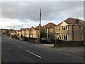
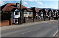
Kingley Road, Stroud
Viewed from Cashes Green Road.
Image: © Jaggery
Taken: 17 Feb 2013
0.07 miles
2
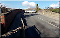
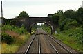
Cashes Green Road railway bridge, Stroud
The bridge, identifier 103 21 SWM, carries the road over railway lines c2km west of Stroud railway station.
Image: © Jaggery
Taken: 17 Feb 2013
0.09 miles
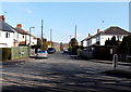
3
Cashes Green Road houses, Stroud
Between Kingley Road behind the camera and Hyett Road ahead.
Image: © Jaggery
Taken: 17 Feb 2013
0.09 miles
4
Cashes Green Road Bridge at Cainscross
Image: © Steve Daniels
Taken: 2 Sep 2009
0.10 miles
5
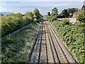
Cashes Green railway Halt (site), Gloucestershire
Opened in 1930 by the Great Western Railway on the line from Swindon to Gloucester, this station closed in 1964.
View west towards Ebley Crossing and Gloucester. No trace appears to remain of the two short parallel platforms here.
Image: © Nigel Thompson
Taken: 9 Oct 2021
0.11 miles
6
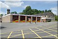
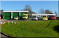
Stroud Fire Station
Stroud Fire Station, Paganhill Lane, Stroud, Gloucestershire is station number W07 of the Gloucestershire Fire & Rescue Service.
Image: © Kevin Hale
Taken: 28 May 2006
0.15 miles
7
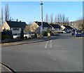
Corner of Mill Farm Drive and Marling Crescent, Stroud
On the left, Marling Crescent heads away from Mill Farm Drive.
Image: © Jaggery
Taken: 15 Jan 2012
0.15 miles
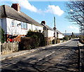
8
Cashes Green Road houses south of the railway, Stroud
This http://www.geograph.org.uk/photo/3822948 bridge is a few metres behind the camera.
Image: © Jaggery
Taken: 17 Feb 2013
0.15 miles
9
Stroud Ambulance Station
Set back from the west side of Paganhill Lane, between the fire station http://www.geograph.org.uk/photo/3537697 and railway lines.
Image: © Jaggery
Taken: 15 Jan 2012
0.15 miles