IMAGES TAKEN NEAR TO
Paganhill Lane, STROUD, GL5 4JT
Introduction
This page details the photographs taken nearby to Paganhill Lane, GL5 4JT by members of the Geograph project.
The Geograph project started in 2005 with the aim of publishing, organising and preserving representative images for every square kilometre of Great Britain, Ireland and the Isle of Man.

There are currently over 7.5m images from over14,400 individuals and you can help contribute to the project by visiting https://www.geograph.org.uk
Image Map (Loading...)


Getting Data...Please wait
Leaflet Map data © OpenStreetMap
Images are licensed for reuse under creativecommons.org/licenses/by-sa/2.0
Notes
- Clicking on the map will re-center to the selected point.
- The higher the marker number, the further away the image location is from the centre of the postcode.
Image Listing (129 Images Found)
Images are licensed for reuse under creativecommons.org/licenses/by-sa/2.0
Image
Details
Distance
1
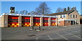
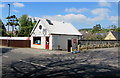
Stroud Community Fire and Rescue Station
Viewed across Paganhill Lane. The station is part of the Gloucestershire Fire & Rescue Service.
An ambulance station is nearby. http://www.geograph.org.uk/photo/3537766
Image: © Jaggery
Taken: 15 Jan 2012
0.02 miles
3
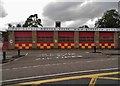
Stroud Fire Station
Stroud Fire Station, Paganhill Lane, Stroud, Gloucestershire is station number W07 of the Gloucestershire Fire & Rescue Service.
Image: © Kevin Hale
Taken: 28 May 2006
0.03 miles
4
Stroud Ambulance Station
Set back from the west side of Paganhill Lane, between the fire station http://www.geograph.org.uk/photo/3537697 and railway lines.
Image: © Jaggery
Taken: 15 Jan 2012
0.04 miles
5
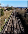
Towards Stroud railway station from Cashes Green Road
Looking NE from this http://www.geograph.org.uk/photo/3822948 bridge. Not in shot, Stroud station is about 2km ahead.
Image: © Jaggery
Taken: 17 Feb 2013
0.06 miles
6
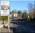
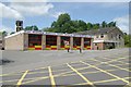
SW approach to Stroud fire station and ambulance station
A view along Paganhill Lane towards the fire station http://www.geograph.org.uk/photo/3537697 and ambulance station. http://www.geograph.org.uk/photo/3537766
Image: © Jaggery
Taken: 15 Jan 2012
0.06 miles
7
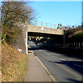
Paganhill Lane railway bridge, Stroud
The A4171 Paganhill Lane passes under a bridge carrying railway lines.
Headroom (overhead clearance) is shown as 15' 9".
Image: © Jaggery
Taken: 15 Jan 2012
0.06 miles
8

Majestic Wine Warehouse, Stroud
Viewed across the A419 Cainscross Road. The previous occupier of the building was Stroud Saddlery.
Image: © Jaggery
Taken: 17 Feb 2013
0.06 miles
9
D.A. Cook Heating premises in Stroud
Heating contractor at 196 Cainscross Road.
Image: © Jaggery
Taken: 7 May 2017
0.07 miles
10
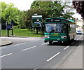
Stroud Valleys bus in Cainscross, Stroud
The 5 litre Leyland National diesel powered bus built in 1976 is heading towards Stroud town centre on the A419 Cainscross Road on a nostalgia trip in May 2017. The old bus is a reminder that for ten years (1983-1993) Stroud's buses operated under its own unique brand, Stroud Valleys. Stagecoach now operates the buses in the Stroud area.
Image: © Jaggery
Taken: 7 May 2017
0.08 miles