1
Welcome to the Parish of Cainscross, Stroud
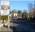
The sign on the right faces the A419 Cainscross Road on the approach to Cainscross Roundabout.
Image: © Jaggery
Taken: 7 May 2017
0.04 miles
2
Houses at the northern end of Westward Road, Cainscross
Viewed across the B4008. The houses are opposite Cainscross Roundabout.
Beyond the right edge of the view, Westward Road becomes Paganhill Lane.
Image: © Jaggery
Taken: 15 Jan 2012
0.04 miles
3
Stroud boundary sign alongside Cainscross Road
The western edge of town, although adjacent Cainscross is usually considered part of Stroud.
Image: © Jaggery
Taken: 17 Feb 2013
0.04 miles
4
SW approach to Stroud fire station and ambulance station
A view along Paganhill Lane towards the fire station http://www.geograph.org.uk/photo/3537697 and ambulance station. http://www.geograph.org.uk/photo/3537766
Image: © Jaggery
Taken: 15 Jan 2012
0.04 miles
5
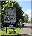
Directions sign, Cainscross Road, Stroud
Facing the A419 Cainscross Road on the approach to Cainscross Roundabout.
Image: © Jaggery
Taken: 7 May 2017
0.05 miles
6
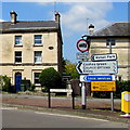
Westward Road direction and distances signs, Cainscross, Stroud
Pointing southwestwards along the B4008 Westward Road half a mile from
Cashes Green and Council Offices and three-quarters of a mile from Ebley.
Image: © Jaggery
Taken: 7 May 2017
0.05 miles
7
Cainscross, milestone
On Westward Road next to the roundabout, milestone with urn and sundial. A plate on the stone gives the distance to Stroud, 1 mile; the urn is inscribed with religious exhortations. Listed by English Heritage, http://www.imagesofengland.org.uk/Details/default.aspx?pid=2&id=131400
Image: © Mike Faherty
Taken: 3 Oct 2010
0.05 miles
8
Shop and billboards, Stroud
Billboards are to the left of D.A.Cook Heating at 196 Cainscross Road.
Out of shot on the right is Majestic Wine Warehouse. http://www.geograph.org.uk/photo/3823012
Image: © Jaggery
Taken: 17 Feb 2013
0.05 miles
9
The start of the 2010 Stroud Half-Marathon
This picture was taken some 50 minutes before the start of the Stroud Half-Marathon near the Cainscross roundabout.
Image: © Roger Davies
Taken: 24 Oct 2010
0.05 miles
10
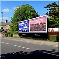
Clear Channel advertising boards, Cainscross Road, Stroud
In early May 2017 one board displays a BT Wi-Fi advert. The other one advertises
the Royal International Air Tattoo to be held at RAF Fairford from July 14-16 2017.
A Virgin Media telecoms cabinet is on the right.
Image: © Jaggery
Taken: 7 May 2017
0.05 miles


