IMAGES TAKEN NEAR TO
Kings Road, STROUD, GL5 3SA
Introduction
This page details the photographs taken nearby to Kings Road, GL5 3SA by members of the Geograph project.
The Geograph project started in 2005 with the aim of publishing, organising and preserving representative images for every square kilometre of Great Britain, Ireland and the Isle of Man.

There are currently over 7.5m images from over14,400 individuals and you can help contribute to the project by visiting https://www.geograph.org.uk
Image Map
Images are licensed for reuse under creativecommons.org/licenses/by-sa/2.0
Notes
- Clicking on the map will re-center to the selected point.
- The higher the marker number, the further away the image location is from the centre of the postcode.
Image Listing (104 Images Found)
Images are licensed for reuse under creativecommons.org/licenses/by-sa/2.0
Image
Details
Distance
1
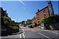
Rodborough Hill
A long steep residential road climbing out of Stroud.
Image: © Bill Boaden
Taken: 22 Jul 2016
0.04 miles
2
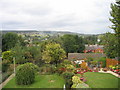
Rodborough Hill
View from Rodborough Hill looking north over Beeches Green with Whiteshill in the distance.
Image: © Tamara Kwan
Taken: 28 Sep 2005
0.04 miles
4
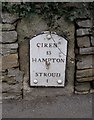
Old Milestone by Rodborough Hill, The Butts, Stroud
Metal plate attached to stone post by the UC road, in parish of RODBOROUGH (STROUD District), Rodborough Hill, inset into wall between Hillside and Rockville, just South of Prince Albert pub, on East side of road. Cirencester roundhead iron plate, erected by the Cirencester to Stroud turnpike trust in the 19th century.
Inscription reads:-
CIRENᴿ.
13
HAMPTON
3
STROUD
1
Milestone Society National ID: GL_CISD13
Image: © M Faherty
Taken: 11 Mar 2011
0.09 miles
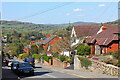
5
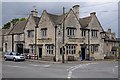
Prince Albert, Rodborough
A popular venue for pub gigs.
Image: © Philip Halling
Taken: 11 Oct 2014
0.13 miles
6
Spillmans Pitch, Rodborough, Stroud
Viewed from the edge of Bath Road looking towards Spillmans Road 150 metres ahead.
Image: © Jaggery
Taken: 28 Dec 2014
0.13 miles
7
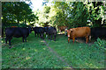
Cows across the path
They were making the most of the shade on this hot day.
Image: © Bill Boaden
Taken: 22 Jul 2016
0.15 miles
8
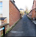
Lower Spillmans, Rodborough, Stroud
Lane on the SE side of the A46 Bath Road.
Image: © Jaggery
Taken: 28 Dec 2014
0.16 miles
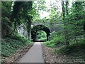
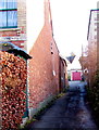
10
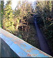
Track on a former railway route, Rodborough, Stroud
Viewed from this http://www.geograph.org.uk/photo/4526754 Bath Road bridge.
The width of the track between steep banks suggests that this was a single-track railway line.
Image: © Jaggery
Taken: 28 Dec 2014
0.16 miles