IMAGES TAKEN NEAR TO
Rodborough Hill, STROUD, GL5 3RT
Introduction
This page details the photographs taken nearby to Rodborough Hill, GL5 3RT by members of the Geograph project.
The Geograph project started in 2005 with the aim of publishing, organising and preserving representative images for every square kilometre of Great Britain, Ireland and the Isle of Man.

There are currently over 7.5m images from over14,400 individuals and you can help contribute to the project by visiting https://www.geograph.org.uk
Image Map
Images are licensed for reuse under creativecommons.org/licenses/by-sa/2.0
Notes
- Clicking on the map will re-center to the selected point.
- The higher the marker number, the further away the image location is from the centre of the postcode.
Image Listing (160 Images Found)
Images are licensed for reuse under creativecommons.org/licenses/by-sa/2.0
Image
Details
Distance
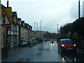
1
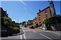
Rodborough Hill
A long steep residential road climbing out of Stroud.
Image: © Bill Boaden
Taken: 22 Jul 2016
0.07 miles
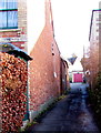
2
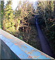
Track on a former railway route, Rodborough, Stroud
Viewed from this http://www.geograph.org.uk/photo/4526754 Bath Road bridge.
The width of the track between steep banks suggests that this was a single-track railway line.
Image: © Jaggery
Taken: 28 Dec 2014
0.08 miles
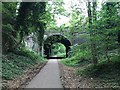
4
Up Rodborough Hill, Stroud
Rodborough Hill climbs away from the A46 Bath Road. A nearby sign http://www.geograph.org.uk/photo/4526695 shows a 1 in 8 gradient.
Image: © Jaggery
Taken: 28 Dec 2014
0.09 miles
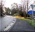
5
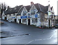
The Clothiers Arms, Rodborough, Stroud
Pub with accommodation and restaurant viewed across the A46 Bath Road in the parish of Rodborough.
Image: © Jaggery
Taken: 28 Dec 2014
0.10 miles
6
Lower Spillmans, Rodborough, Stroud
Lane on the SE side of the A46 Bath Road.
Image: © Jaggery
Taken: 28 Dec 2014
0.10 miles
8
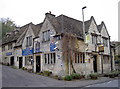
The Clothiers Arms
Stroud has a long history in the wool trade so not surprisingly there is a reminder.
Image: © Neil Owen
Taken: 25 Nov 2013
0.11 miles
9
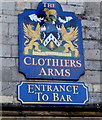
The Clothiers Arms heraldic name sign, Rodborough Stroud
Over a doorway here. http://www.geograph.org.uk/photo/4292494
Image: © Jaggery
Taken: 28 Dec 2014
0.11 miles
10
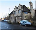
The Clothiers Arms, Rodborough, Stroud
Pub with accommodation and restaurant viewed across the A46 Bath Road in the parish of Rodborough.
Image: © Jaggery
Taken: 28 Dec 2014
0.11 miles