IMAGES TAKEN NEAR TO
Lower Spillmans, STROUD, GL5 3RN
Introduction
This page details the photographs taken nearby to Lower Spillmans, GL5 3RN by members of the Geograph project.
The Geograph project started in 2005 with the aim of publishing, organising and preserving representative images for every square kilometre of Great Britain, Ireland and the Isle of Man.

There are currently over 7.5m images from over14,400 individuals and you can help contribute to the project by visiting https://www.geograph.org.uk
Image Map
Images are licensed for reuse under creativecommons.org/licenses/by-sa/2.0
Notes
- Clicking on the map will re-center to the selected point.
- The higher the marker number, the further away the image location is from the centre of the postcode.
Image Listing (151 Images Found)
Images are licensed for reuse under creativecommons.org/licenses/by-sa/2.0
Image
Details
Distance
1
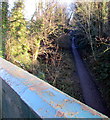
Track on a former railway route, Rodborough, Stroud
Viewed from this http://www.geograph.org.uk/photo/4526754 Bath Road bridge.
The width of the track between steep banks suggests that this was a single-track railway line.
Image: © Jaggery
Taken: 28 Dec 2014
0.04 miles
2
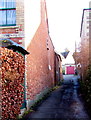
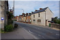
Lower Spillmans, Rodborough, Stroud
Lane on the SE side of the A46 Bath Road.
Image: © Jaggery
Taken: 28 Dec 2014
0.05 miles
3
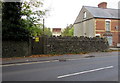
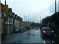
Electricity substation, Bath Road, Rodborough, Stroud
The Western Power Distribution electricity substation is behind a stone wall on the north side of Bath Road.
Image: © Jaggery
Taken: 18 Oct 2015
0.05 miles
4
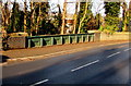
Bath Road bridge over a former railway, Rodborough, Stroud
A 1930s map shows a railway line passing under this bridge.
Image: © Jaggery
Taken: 28 Dec 2014
0.05 miles
5
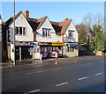
Bath Road Stores and Bengal Balti in Rodborough, Stroud
The Premier Express Bath Road Stores is next door to
Bengal Balti & Tandoori takeaway on the left at 60 Bath Road, Rodborough.
Image: © Jaggery
Taken: 28 Dec 2014
0.08 miles
9
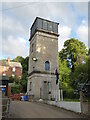
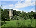
Water tower near Lodgemore Mill, Stroud
This is alongside the sea scout training centre.
Image: © Chris Allen
Taken: 14 Jun 2018
0.08 miles
10
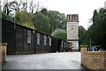
Water tower near Lodgemore Mills, Stroud
This is alongside the sea scout training centre.
Image: © Chris Allen
Taken: 27 Oct 2013
0.08 miles