IMAGES TAKEN NEAR TO
Baytree Square North, STROUD, GL5 3AE
Introduction
This page details the photographs taken nearby to Baytree Square North, GL5 3AE by members of the Geograph project.
The Geograph project started in 2005 with the aim of publishing, organising and preserving representative images for every square kilometre of Great Britain, Ireland and the Isle of Man.

There are currently over 7.5m images from over14,400 individuals and you can help contribute to the project by visiting https://www.geograph.org.uk
Image Map
Images are licensed for reuse under creativecommons.org/licenses/by-sa/2.0
Notes
- Clicking on the map will re-center to the selected point.
- The higher the marker number, the further away the image location is from the centre of the postcode.
Image Listing (146 Images Found)
Images are licensed for reuse under creativecommons.org/licenses/by-sa/2.0
Image
Details
Distance
1
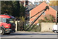
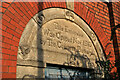
Stroudwater Canal - crane
Preserved wooden jib, manual crane at the former Dudbridge Wharf. Built 1854 by John Stevenson, Canal Foundry, Preston and rated at 5 tons.
Image: © Chris Allen
Taken: 23 Nov 2013
0.05 miles
2
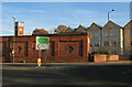
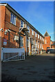
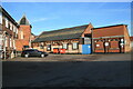
Dudbridge Mills, Stroud
Former textile mills that were later used by Redlers to manufacture conveyors. The part visible here is a single storey brick extension from 1910. The stone building and brick tower behind are on parts of the site that has been converted to accommodation.
Image: © Chris Allen
Taken: 23 Nov 2013
0.05 miles
3
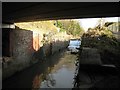
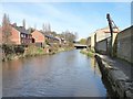
Dudbridge Road bridge and lock
This length of the Stroudwater Canal was converted into a flood relief channel in 1956 and the locks here at Dudbridge road had their gates removed and weirs installed. This is the lower, or Franklin's Lock (named after the builder) and forms a single structure with Dudbridge Road bridge. The lock chamber is generally in good condition and the main restoration work will be the provision of new gates and paddles, along with additional bypass culverts to maintain the flood flow capability.
Image: © David Stowell
Taken: 9 Jan 2008
0.05 miles
4
Dudbridge Mills, Stroud
Former textile mills that were later used by Redlers to manufacture conveyors. The extension here with the north light roof was opened in 1910 and is alongside the River Frome.
Image: © Chris Allen
Taken: 23 Nov 2013
0.05 miles
5
Dudbridge Mills, Stroud - commemorative plaque
This extension in red brick with a north light roof was opened in 1910. The mill was originally used in textile manufacture but was latterly used by Redler to manufacture conveyors. I think this section might have been disused when I took this view.
Image: © Chris Allen
Taken: 23 Nov 2013
0.05 miles
6
Crane, Dudbridge Wharf, Stroudwater Navigation
This is the last surviving crane on the Cotswolds Canals. It replaced an earlier crane in 1854, at a cost of just over £200. For a view from the land-side, see Image
Image: © Christine Johnstone
Taken: 28 Mar 2016
0.06 miles
7
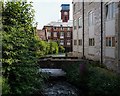
River Frome at Dudbridge, Stroud
Flowing between the offices of Redlers and the mill now converted to apartments.
Image: © Roger May
Taken: 26 Jul 2012
0.06 miles
8
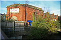
Dudbridge Mills, Stroud
Former textile mills that were later used by Redlers to manufacture conveyors. The part visible here is, I think, in multiple occupancy. Part of the site has been converted to housing and is behind automatic gates that restrict the available views.
Image: © Chris Allen
Taken: 23 Nov 2013
0.06 miles
9
Dudbridge Mills, Stroud
Former textile mills that were later used by Redlers to manufacture conveyors. The part visible here is, I think, in multiple occupancy. Part of the site has been converted to housing and is behind automatic gates that restrict the available views.
Image: © Chris Allen
Taken: 23 Nov 2013
0.07 miles
10
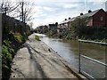
Stroudwater Navigation, west of Dudbridge Road
The towpath is also the Thames and Severn Way.
Image: © Christine Johnstone
Taken: 28 Mar 2016
0.07 miles