IMAGES TAKEN NEAR TO
Greenhills Close, CHELTENHAM, GL53 9EY
Introduction
This page details the photographs taken nearby to Greenhills Close, GL53 9EY by members of the Geograph project.
The Geograph project started in 2005 with the aim of publishing, organising and preserving representative images for every square kilometre of Great Britain, Ireland and the Isle of Man.

There are currently over 7.5m images from over14,400 individuals and you can help contribute to the project by visiting https://www.geograph.org.uk
Image Map
Images are licensed for reuse under creativecommons.org/licenses/by-sa/2.0
Notes
- Clicking on the map will re-center to the selected point.
- The higher the marker number, the further away the image location is from the centre of the postcode.
Image Listing (32 Images Found)
Images are licensed for reuse under creativecommons.org/licenses/by-sa/2.0
Image
Details
Distance
1
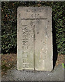
Old Boundary Marker
Municipal Boundary Marker on the north side of the junction where Greenhills Road meets Charlton Lane. The boundary of Cheltenham and Charlton Kings parish. Inscribed CHELTENHAM on the left, G. C. C. on the right (both vertically with a vertical dividing line between them) and B. OF C. / 1935 at the top.
Milestone Society National ID: GL_CMCK01pb
Image: © Mr Red
Taken: 11 Mar 2019
0.08 miles
2
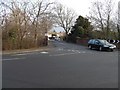
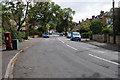
Pilley Bridge Junction, Leckhampton, Cheltenham
This busy road junction carrying traffic to and from Cheltenham from the south and south west and bypassing Cheltenham from east to south/south west, crosses a bridge over the route of the long closed Cheltenham to Banbury railway.
Image: © Terry Jacombs
Taken: 27 Jan 2009
0.10 miles
3
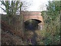
Pilley Bridge, Old Bath Road, Cheltenham
The busy Old Bath Road crosses the route of the long closed Cheltenham to Banbury railway over this bridge.
Image: © Terry Jacombs
Taken: 27 Jan 2009
0.10 miles
4
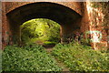
Pilley Bridge Nature Reserve
Now the Pilley Bridge Nature Reserve, originally this was the Cheltenham to Banbury railway line which closed to passengers in October 1962 with freight services ceasing two years later in September 1964. Cheltenham's Old Bath Road passes over the bridge.
Image: © Philip Halling
Taken: 13 Aug 2011
0.10 miles
5
Old Bath Road, Cheltenham
Old Bath Road in the Leckhampton area of Cheltenham.
Image: © Philip Halling
Taken: 13 Aug 2011
0.11 miles
6
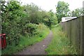
Path from Old Bath Road to Mead Road
The path runs alongside the Pilley Nature Reserve
Image: © Terry Jacombs
Taken: 4 Jul 2012
0.11 miles
7
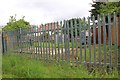
Electricity sub-station
The sub-station is hidden alongside Pilley Nature Reserve
Image: © Terry Jacombs
Taken: 4 Jul 2012
0.12 miles
8
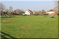
Pilford Avenue playground
The playground is adjacent to the Old Pat's grounds.
Image: © Terry Jacombs
Taken: 23 Mar 2012
0.13 miles
9
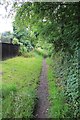
Old Bath Road to Mead Road footpath
The footpath runs alongside the Pilley Nature Reserve
Image: © Terry Jacombs
Taken: 4 Jul 2012
0.13 miles
10
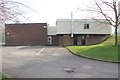
Old Pat's club house
Pates is Cheltenham grammar school. The Old Pat's is the ex school members association.
Image: © Terry Jacombs
Taken: 23 Mar 2012
0.15 miles