IMAGES TAKEN NEAR TO
Mead Close, CHELTENHAM, GL53 7DX
Introduction
This page details the photographs taken nearby to Mead Close, GL53 7DX by members of the Geograph project.
The Geograph project started in 2005 with the aim of publishing, organising and preserving representative images for every square kilometre of Great Britain, Ireland and the Isle of Man.

There are currently over 7.5m images from over14,400 individuals and you can help contribute to the project by visiting https://www.geograph.org.uk
Image Map
Images are licensed for reuse under creativecommons.org/licenses/by-sa/2.0
Notes
- Clicking on the map will re-center to the selected point.
- The higher the marker number, the further away the image location is from the centre of the postcode.
Image Listing (42 Images Found)
Images are licensed for reuse under creativecommons.org/licenses/by-sa/2.0
Image
Details
Distance
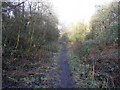
1
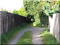
Old Bath Road to Mead Road footpath
The footpath runs between the gardens of houses on the left and a large area of allotments on the right.
Image: © Terry Jacombs
Taken: 25 Sep 2007
0.06 miles
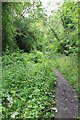
2
Old Bath Road to Mead Road footpath
The footpath runs alongside the Pilley Nature Reserve
Image: © Terry Jacombs
Taken: 4 Jul 2012
0.07 miles
4
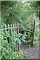
Down to Pilley Nature Reserve
Steps descend through this gap in the fence down to the Pilley Nature Reserve
Image: © Terry Jacombs
Taken: 4 Jul 2012
0.07 miles
5
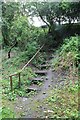
Steps down to Pilley Nature Reserve
The steps were very slippy in this wet non-existent summer of 2012
Image: © Terry Jacombs
Taken: 4 Jul 2012
0.07 miles
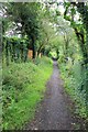
6
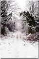
View along path in Pilley Bridge Nature Reserve
Winter view in Pilley Bridge Nature Reserve, Leckhampton, Cheltenham.
Image: © Rob Dewey
Taken: 10 Dec 2017
0.08 miles
7
Pilley Nature Reserve west of Pilley Bridge
This footpath runs along the route of the long closed Cheltenham to Banbury railway line. About 400 metres or so along this part has been made into a small nature reserve in the heart of residential south Cheltenham.
Image: © Terry Jacombs
Taken: 27 Jan 2009
0.08 miles
8
Pilley Nature Reserve
The Reserve occupies the old track bed of the Cheltenham to Andoversford railway line
Image: © Terry Jacombs
Taken: 4 Jul 2012
0.08 miles
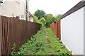
9
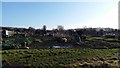
Asquith Road Allotments
The allotments cover all the ground south of Naunton Park between the Old Bath Road and Asquith Road.
Image: © Terry Jacombs
Taken: 18 Jan 2009
0.09 miles
10
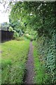
Old Bath Road to Mead Road footpath
The footpath runs alongside the Pilley Nature Reserve
Image: © Terry Jacombs
Taken: 4 Jul 2012
0.10 miles