
IMAGES TAKEN NEAR TO
Silverthorn Close, CHELTENHAM, GL53 0JF
Introduction
This page details the photographs taken nearby to Silverthorn Close, GL53 0JF by members of the Geograph project.
The Geograph project started in 2005 with the aim of publishing, organising and preserving representative images for every square kilometre of Great Britain, Ireland and the Isle of Man.

There are currently over 7.5m images from over14,400 individuals and you can help contribute to the project by visiting https://www.geograph.org.uk
Image Map
Images are licensed for reuse under creativecommons.org/licenses/by-sa/2.0
Notes
- Clicking on the map will re-center to the selected point.
- The higher the marker number, the further away the image location is from the centre of the postcode.
Image Listing (6 Images Found)
Images are licensed for reuse under creativecommons.org/licenses/by-sa/2.0
Image
Details
Distance
1
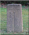
Old Boundary Marker
Municipal Boundary Marker on verge beside drive to house on south side of the A46 Shurdington Road. On the boundary between Cheltenham Borough and Leckhampton parish, Gloucestershire. Inscribed CHELTENHAM │ G C C (both vertical) on its centre face, with B OF C / 1935 above.
Milestone Society National ID: GL_LECCHE01pb
Image: © Mr Red
Taken: 22 Feb 2019
0.07 miles
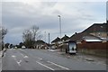
3
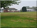
Bournside School
These playing fields serve Bournside, Bettridge and Belmont Schools.
Image: © Stephen Bowden
Taken: 23 Apr 2005
0.17 miles
4
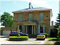
Arundel Lodge, The Park, Cheltenham
Fairly typical of the estate's villas of the 1840s to 1850s, this one with a Greek Doric porch. Grade II listed.
Image: © Stephen Richards
Taken: 21 May 2015
0.21 miles
5

Saving Leckhampton's fields?
Well the good local folks are trying to stave off the developers on this green belt land on the southern edge of Cheltenham.
We'll see in a few years time.
Image: © Jonathan Billinger
Taken: 12 Dec 2014
0.22 miles
6

Junction on Shurdington Road
Kidnappers Lane meets the A46.
The contentious green belt vs. development land is just to the right of the hedge here. See Image
Image: © Jonathan Billinger
Taken: 12 Dec 2014
0.23 miles