IMAGES TAKEN NEAR TO
Spinney Court, STROUD, GL5 2PY
Introduction
This page details the photographs taken nearby to Spinney Court, GL5 2PY by members of the Geograph project.
The Geograph project started in 2005 with the aim of publishing, organising and preserving representative images for every square kilometre of Great Britain, Ireland and the Isle of Man.

There are currently over 7.5m images from over14,400 individuals and you can help contribute to the project by visiting https://www.geograph.org.uk
Image Map
Images are licensed for reuse under creativecommons.org/licenses/by-sa/2.0
Notes
- Clicking on the map will re-center to the selected point.
- The higher the marker number, the further away the image location is from the centre of the postcode.
Image Listing (100 Images Found)
Images are licensed for reuse under creativecommons.org/licenses/by-sa/2.0
Image
Details
Distance
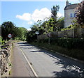
1
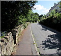
The Roundabouts, Brimscombe
Viewed from near a gap in the wall, a side entrance to Holy Trinity Church. http://www.geograph.org.uk/photo/4688467
From this view, the reason for the name of the road, The Roundabouts, is unclear.
Maps show that The Roundabouts is indeed a roundabout road. Its complete course resembles a triangle.
Image: © Jaggery
Taken: 6 Sep 2015
0.03 miles
2
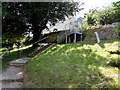
Steep exit from Holy Trinity churchyard, Brimscombe
The churchyard is on a steep slope between The Roundabouts (ahead) and Brimscombe Hill.
Image: © Jaggery
Taken: 6 Sep 2015
0.04 miles
3
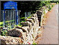
Welcome to the Parish Church of Holy Trinity, Brimscombe
A gap in The Roundabouts wall leads to the steps seen here. http://www.geograph.org.uk/photo/4691274
Image: © Jaggery
Taken: 6 Sep 2015
0.04 miles
4
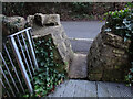
Stone Stile, Brimscombe
Pedestrian access to Briscombe Holy Trinity church churchyard. This view is looking to the road, "Roundabouts".
Image: © Mr Red
Taken: 31 Dec 2021
0.05 miles
5
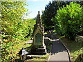
Distinctive memorial in Holy Trinity churchyard, Brimscombe
On the southern (upper) side of the steeply sloping churchyard.
Image: © Jaggery
Taken: 6 Sep 2015
0.05 miles
6
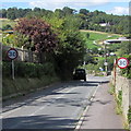
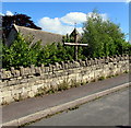
From 40 to 30 on The Roundabouts, Brimscombe
The 40mph speed limit decreases to 30 on the descent along the road named The Roundabouts towards houses alongside Brimscombe Hill. On the right is the perimeter wall at the top of Holy Trinity churchyard.
Image: © Jaggery
Taken: 6 Sep 2015
0.05 miles
7
From 30 to 40 on The Roundabouts, Brimscombe
The 30mph speed limit past houses behind the camera increases to 40mph.
The wall on the left is the perimeter wall at the top of Holy Trinity churchyard.
Image: © Jaggery
Taken: 6 Sep 2015
0.05 miles
8
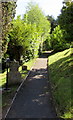
Path through the southern edge of Holy Trinity churchyard, Brimscombe
This view shows the sloping nature of the churchyard -
steep slope on the right and the top of the slope on the left.
Image: © Jaggery
Taken: 6 Sep 2015
0.06 miles
9
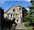
Holy Trinity Church, Brimscombe
Located in a steeply sloping churchyard between The Roundabouts and Brimscombe Hill.
The church and churchyard are accessed from The Roundabouts.
Holy Trinity Brimscombe is in the Church of England Diocese of Gloucester.
The church website states that the foundation stone was laid on June 6th 1839. The building was consecrated on April 7th 1840. Because of the shape of the land and the steep slope, the church was built the wrong way round, to fit onto the site. (Various local legends give other reasons!) The nave, usually at the east end of a church, faces west.
Image: © Jaggery
Taken: 6 Sep 2015
0.06 miles
10
Wooden cross at a churchyard perimeter wall, Brimscombe
On the north side of Holy Trinity http://www.geograph.org.uk/photo/4688467 churchyard.
Image: © Jaggery
Taken: 6 Sep 2015
0.06 miles