1
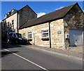
Bell Cottage and The Bell, Burleigh
Viewed across Brimscombe Hill.
Bell Cottage is on the right (entrance via a footpath). The Bell is the house on the left.
Image: © Jaggery
Taken: 6 Sep 2015
0.00 miles
2
Entrance to Coopers Building & Maintenance, Burleigh
Premises of C.H Cooper & Son (Building) Ltd viewed from Brimscombe Hill.
Image: © Jaggery
Taken: 6 Sep 2015
0.02 miles
3
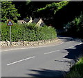
Cattle grid warning sign, Brimscombe Hill, Burleigh
On the descent towards this http://www.geograph.org.uk/photo/4717796 cattle grid.
Image: © Jaggery
Taken: 6 Sep 2015
0.02 miles
4
Roadside houses, Burleigh
Houses alongside and below Brimscombe Hill in the Gloucestershire Cotswolds.
Image: © Jaggery
Taken: 6 Sep 2015
0.04 miles
5
Up Brimscombe Hill, Burleigh
Brimscombe Hill ascends towards common land where cattle roam freely.
The road grid prevents cattle crossing to this side.
Image: © Jaggery
Taken: 6 Sep 2015
0.06 miles
6
Steep side road, Burleigh
Dead-end road descending from Brimscombe Hill to Claycombe.
Image: © Jaggery
Taken: 6 Sep 2015
0.08 miles
7
Cattle grid across Brimscombe Hill, Burleigh
The gate on the left lets horse riders bypass the grid.
Image: © Jaggery
Taken: 6 Sep 2015
0.08 miles
8
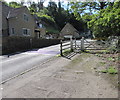
Two gates alongside a cattle grid, Burleigh
The grid is across Brimscombe Hill. Walkers can use the small gate to bypass the grid.
The wider gate is for horsedrawn vehicles and people leading animals.
BEWARE CATTLE ON ROAD is etched on the wider gate.
Image: © Jaggery
Taken: 6 Sep 2015
0.08 miles
9
Old Boundary Stone, Minchinhampton Common
Along Gloucestershire footpath MMH26 against the property wall of "Knapping", in a triangle bounded by: Jacob's Knowle, Claycombe and Beechknapp. The Common is owned by the National Trust, and is principally for: recreation, a golf course on part of it, and grazing for cattle in the warmer months which is administered by an officer called a "hayward".
Inscription: H C / 1865
Milestone Society National ID: GL_MINCH03em
Image: © Ian Kenny Roberts
Taken: 28 Mar 2022
0.09 miles
10
Minchinhampton Common name sign, Burleigh
The National Trust sign is alongside Brimscombe Hill on the approach to common land in the Gloucestershire Cotswolds.
Image: © Jaggery
Taken: 6 Sep 2015
0.09 miles


