IMAGES TAKEN NEAR TO
Murray Close, CHELTENHAM, GL52 8XE
Introduction
This page details the photographs taken nearby to Murray Close, GL52 8XE by members of the Geograph project.
The Geograph project started in 2005 with the aim of publishing, organising and preserving representative images for every square kilometre of Great Britain, Ireland and the Isle of Man.

There are currently over 7.5m images from over14,400 individuals and you can help contribute to the project by visiting https://www.geograph.org.uk
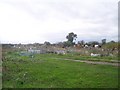
Image Map
Images are licensed for reuse under creativecommons.org/licenses/by-sa/2.0
Notes
- Clicking on the map will re-center to the selected point.
- The higher the marker number, the further away the image location is from the centre of the postcode.
Image Listing (21 Images Found)
Images are licensed for reuse under creativecommons.org/licenses/by-sa/2.0
Image
Details
Distance
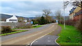
1
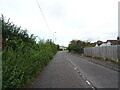
Evesham Road, Bishop's Cleeve
Looking north on the former A435.
Image: © JThomas
Taken: 13 Aug 2021
0.04 miles
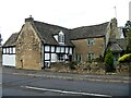
2
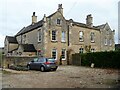
Bishop's Cleeve houses [8]
The former Cleeveway Hotel in Evesham Road was built as a house, converted into a hotel and then converted into several separate dwellings. Built, possible, in the late 18th century and extended and altered in the late 19th century. Constructed of squared, coursed limestone with freestone quoins and ashlar dressings, all under a stone slate roof. Listed, grade II, with details at: https://historicengland.org.uk/listing/the-list/list-entry/1091734
Bishop's Cleeve is a large village in Gloucestershire. It lies at the foot of Cleeve Hill, the highest point of the Cotswolds, some 3½ miles north of Cheltenham. Although Iron Age and Roman remains have been found locally, the earliest known origins of the village date to the 8th Century. A monastery and surrounding land was given to the Bishop of Worcester, and the village became the Bishop’s Cliffe. The village grew rapidly when an aerospace factory was built nearby after the Second World War and continues to grow.
Image: © Michael Dibb
Taken: 9 Nov 2021
0.09 miles

4
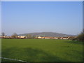
Nottingham Hill
The view towards Nottingham Hill taken from the fields near Dean Farm
Image: © Rob Coldwell
Taken: 1 Apr 2007
0.12 miles
5
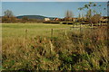
Housing on the edge of Bishop's Cleeve
In twenty years or so the village of Bishop's Cleeve has grown enormously, the houses in this view are on the edge of the village adjoining the A435.
Image: © Philip Halling
Taken: 6 Dec 2009
0.13 miles
6
Nortenham Allotments, Bishop's Cleeve
On the outside of the new by-pass close to Dean Farm. The original allotment site is ready for infill development.
Image: © Bob Embleton
Taken: 11 Nov 2005
0.16 miles
7
Bishop's Cleeve houses [7]
Number 18 Evesham Road and number 20 Evesham Road are semi-detached cottages.
Number 18 was built in the 17th century and extended in the 19th century. Constructed of square-panelled timber framing extended or partly encased in squared, coursed limestone under a stone slate roof. There is a rear extension in brick. Listed, grade II, with details at: https://historicengland.org.uk/listing/the-list/list-entry/1154126
Number 20 was built in the late 17th or early 18th century. Constructed of square-panelled timber framing with rendered infill on a rendered plinth with the gable wall to the street of squared, coursed limestone, all under a stone slate roof. Listed, grade II, with details at: https://historicengland.org.uk/listing/the-list/list-entry/1091735
Bishop's Cleeve is a large village in Gloucestershire. It lies at the foot of Cleeve Hill, the highest point of the Cotswolds, some 3½ miles north of Cheltenham. Although Iron Age and Roman remains have been found locally, the earliest known origins of the village date to the 8th Century. A monastery and surrounding land was given to the Bishop of Worcester, and the village became the Bishop’s Cliffe. The village grew rapidly when an aerospace factory was built nearby after the Second World War and continues to grow.
Image: © Michael Dibb
Taken: 9 Nov 2021
0.16 miles
8
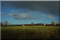
Rainbow over Bishop's Cleeve
A shower of rain over Bishop's Cleeve has produced this rainbow. The hill in shadow on the horizon is Oxenton Hill.
Image: © Philip Halling
Taken: 6 Dec 2009
0.17 miles
9
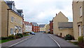
Greenacre Way, Bishop's Cleeve
Recently built townscape-style housing on the northern edge of this dormitory town.
Image: © Jonathan Billinger
Taken: 25 Jan 2012
0.18 miles
10
The Old Evesham Road
Looking south towards the dormitory town of Bishop's Cleeve and the Cotswold scarp beyond.
Image: © Jonathan Billinger
Taken: 25 Jan 2012
0.20 miles