
IMAGES TAKEN NEAR TO
Huntsmans Close, CHELTENHAM, GL52 8JG
Introduction
This page details the photographs taken nearby to Huntsmans Close, GL52 8JG by members of the Geograph project.
The Geograph project started in 2005 with the aim of publishing, organising and preserving representative images for every square kilometre of Great Britain, Ireland and the Isle of Man.

There are currently over 7.5m images from over14,400 individuals and you can help contribute to the project by visiting https://www.geograph.org.uk
Image Map
Images are licensed for reuse under creativecommons.org/licenses/by-sa/2.0
Notes
- Clicking on the map will re-center to the selected point.
- The higher the marker number, the further away the image location is from the centre of the postcode.
Image Listing (180 Images Found)
Images are licensed for reuse under creativecommons.org/licenses/by-sa/2.0
Image
Details
Distance
2
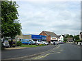
Bishop's Cleeve The Original Factory Shop Tobyfield Road
Image: © Roy Hughes
Taken: 23 May 2015
0.05 miles
4
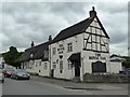
The Royal Oak
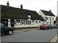
The Royal Oak in Bishop's Cleeve, the building dates from the early 17th century and is Grade II listed. https://www.historicengland.org.uk/listing/the-list/list-entry/1091696
Image: © Philip Halling
Taken: 28 Apr 2017
0.06 miles
5
The Royal Oak, Bishop's Cleeve
The Royal Oak in Bishop's Cleeve, the building dates from the early 17th century and is Grade II listed. https://www.historicengland.org.uk/listing/the-list/list-entry/1091696
Image: © Philip Halling
Taken: 28 Apr 2017
0.06 miles
7
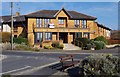
Rectory Court, School Road, Bishop's Cleeve, Glos
A large development of one and two bed retirement apartments with resident management staff and community alarm system. The development was built in 1987.
Image: © P L Chadwick
Taken: 6 Apr 2013
0.07 miles
8

Bishop's Cleeve War Memorial, Church Road, Bishop's Cleeve, Glos
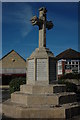
The text on the middle panel on this side reads:- "To the Greater Glory of God and in loving memory of those men belonging to this Parish who laid down their lives in the Great war. May they rest in peace." The other two panels on this side of the memorial contain lists of names of some of the fallen from the First (Great) World War. Other panels record the remainder of the names from that war and those who fell in the Second World War.
The memorial was unveiled on the 25th September 1919, but originally it was positioned elsewhere. It was moved by the Army, at a much later date, to its present position but unfortunately they managed to damage it in the process. As a result the shaft under the cross is much shorter than it originally was.
Image: © P L Chadwick
Taken: 6 Apr 2013
0.07 miles
10
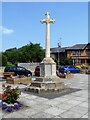
War memorial
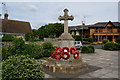
Bishop's Cleeve war memorial in Church Road has recently been renovated. When moved to its present position in 1980, damage was caused to the middle shafts and the repairs have resulted in the memorial being restored to its original appearance. The ashlar memorial was unveiled in 1919.
Bishop's Cleeve is a large village in Gloucestershire. It lies at the foot of Cleeve Hill, the highest point of the Cotswolds, some 3½ miles north of Cheltenham. Although Iron Age and Roman remains have been found locally, the earliest known origins of the village date to the 8th Century. A monastery and surrounding land was given to the Bishop of Worcester, and the village became the Bishop’s Cliffe. The village grew rapidly when an aerospace factory was built nearby after the Second World War and continues to grow.
Image: © Michael Dibb
Taken: 21 Jul 2021
0.07 miles