IMAGES TAKEN NEAR TO
Church Lane, CHELTENHAM, GL52 3AP
Introduction
This page details the photographs taken nearby to Church Lane, GL52 3AP by members of the Geograph project.
The Geograph project started in 2005 with the aim of publishing, organising and preserving representative images for every square kilometre of Great Britain, Ireland and the Isle of Man.

There are currently over 7.5m images from over14,400 individuals and you can help contribute to the project by visiting https://www.geograph.org.uk
Image Map
Images are licensed for reuse under creativecommons.org/licenses/by-sa/2.0
Notes
- Clicking on the map will re-center to the selected point.
- The higher the marker number, the further away the image location is from the centre of the postcode.
Image Listing (179 Images Found)
Images are licensed for reuse under creativecommons.org/licenses/by-sa/2.0
Image
Details
Distance
1
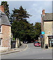
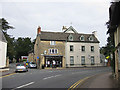
North along Church Lane, Prestbury
Rowlands Pharmacy https://www.geograph.org.uk/photo/6090123 is on the right.
Image: © Jaggery
Taken: 17 Mar 2019
0.03 miles
2

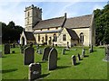
Prestbury Church
Prestbury church is dedicated to St Mary. The church is situated on a grid line separating two grid squares.
Image: © Philip Halling
Taken: 21 Aug 2010
0.04 miles
3
Fenced-off house, Deep Street, Prestbury
Viewed from High Street in March 2019.
Image: © Jaggery
Taken: 17 Mar 2019
0.04 miles
4
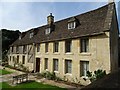
The Priory, Prestbury
The Priory viewed here from the churchyard of St Mary's church. At the time of the dissolution of the monasteries this building was part of the Augustinian Llanthony Priory. The building is Grade II listed, see: https://historicengland.org.uk/listing/the-list/list-entry/1091902
Image: © Philip Halling
Taken: 15 Aug 2019
0.04 miles
5
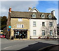
Rowlands Pharmacy, 5 High Street, Prestbury
On the corner of Church Lane.
Image: © Jaggery
Taken: 17 Mar 2019
0.05 miles
6
Prestbury church
St Mary's church in Prestbury dates from the 13th century with later additions. Like many churches it was restored by the Victorians, the work was undertaken 1864-8 by G.E. Street. The church is Grade II* listed, see: https://historicengland.org.uk/listing/the-list/list-entry/1153687
Image: © Philip Halling
Taken: 15 Aug 2019
0.05 miles
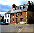
7
Pharmacy and Bed and Breakfast premises
At the junction of High Street and Deep Street.
Image: © Pauline E
Taken: 26 Sep 2009
0.05 miles
8
![Prestbury houses [12]](https://s0.geograph.org.uk/geophotos/06/92/12/6921288_4d3a28ac_120x120.jpg)
Prestbury houses [12]
Reform Cottage, number 9 Deep Street, is a detached cottage, set back from the street. Timber framed with square panelling, mostly clad in weather board, under a thatch roof. Possibly originally a tithe barn for with Llanthony Priory. Listed, grade II, with details at: https://historicengland.org.uk/listing/the-list/list-entry/1091937
The village of Prestbury, occupied since Saxon times, is some 1½ miles northeast of the town of Cheltenham, which it once rivalled as a commercial centre. A market was established in 1249, but it declined and the historic village is now merely a suburb of the larger town. The village is home to Prestbury Park, the Cheltenham Racecourse. The village is reputed to be one of the most haunted places in Britain.
Image: © Michael Dibb
Taken: 20 May 2021
0.05 miles
9
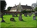
The Priory, Prestbury
Historic building beside the church. Today this Grade II listed building is semi-detached and separated into two properties.
Image: © Philip Halling
Taken: 15 Aug 2019
0.05 miles
10
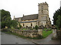
Prestbury Church
Prestbury church is dedicated to St Mary it lies on the boundary of two grid squares here it is viewed from the north.
Image: © Philip Halling
Taken: 21 Aug 2010
0.05 miles