IMAGES TAKEN NEAR TO
Slad Road, STROUD, GL5 1QL
Introduction
This page details the photographs taken nearby to Slad Road, GL5 1QL by members of the Geograph project.
The Geograph project started in 2005 with the aim of publishing, organising and preserving representative images for every square kilometre of Great Britain, Ireland and the Isle of Man.

There are currently over 7.5m images from over14,400 individuals and you can help contribute to the project by visiting https://www.geograph.org.uk
Image Map
Images are licensed for reuse under creativecommons.org/licenses/by-sa/2.0
Notes
- Clicking on the map will re-center to the selected point.
- The higher the marker number, the further away the image location is from the centre of the postcode.
Image Listing (601 Images Found)
Images are licensed for reuse under creativecommons.org/licenses/by-sa/2.0
Image
Details
Distance
1
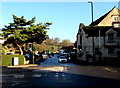
Western end of the B4070 in Stroud
The B4070 is a road from the A46 here in Stroud to Birdlip, about 20km away.
The B4070 ahead is named Slad Road. A sign on the right shows that Slad is 2 miles away.
Image: © Jaggery
Taken: 28 Dec 2014
0.02 miles
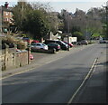
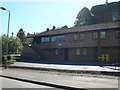
2
Houses above Slad Road, Stroud
Viewed across the B4070 Slad Road in April 2021.
Image: © Jaggery
Taken: 18 Apr 2021
0.02 miles
3
Slad Road buildings, Stroud
Viewed from the entrance http://www.geograph.org.uk/photo/3303827 to Park Gardens. The row of buildings has residential and business properties. The turquoise colour at the right edge of the view is a Lloyds Pharmacy. http://www.geograph.org.uk/photo/3303822
Image: © Jaggery
Taken: 8 Jan 2012
0.02 miles
4
East along Slad Road, Stroud
The B4070 Slad Road viewed from near the corner of Gloucester Street.
Image: © Jaggery
Taken: 18 Apr 2021
0.03 miles
5
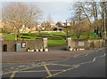
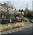
Entrance to Park Gardens, Stroud
The entrance is on the corner of Slad Road and Birches Drive. An inscription in the wall records that the land was presented to Stroud for use as pleasure gardens in October 1927 by Sidney B. Park in memory of his son Herbert Sidney Park who was killed in France on October 26th 1917.
Image: © Jaggery
Taken: 8 Jan 2012
0.03 miles
6
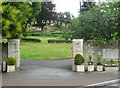
Entrance to Park Gardens, Stroud
Park is the name of the benefactor, so they could have called it Park Park.
Image: © Humphrey Bolton
Taken: 11 Jul 2017
0.03 miles
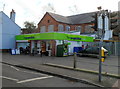
7
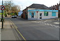
Lloyds Pharmacy, Locking Hill, Stroud
Located on the corner of Slad Road and Locking Hill, opposite Locking Hill Surgery. http://www.geograph.org.uk/photo/3303821
Image: © Jaggery
Taken: 8 Jan 2012
0.03 miles
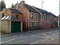
8
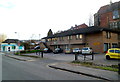
Locking Hill Surgery, Stroud
On the corner of Slad Road and Locking Hall, with a Lloyds Pharmacy on the corner ahead.
Image: © Jaggery
Taken: 8 Jan 2012
0.04 miles
10
The Co-operative Food store, Slad Road, Stroud
Located at 16 Slad Road, opposite Park Gardens.
Image: © Jaggery
Taken: 8 Jan 2012
0.05 miles