IMAGES TAKEN NEAR TO
Denbigh Road, CHELTENHAM, GL51 3JQ
Introduction
This page details the photographs taken nearby to Denbigh Road, GL51 3JQ by members of the Geograph project.
The Geograph project started in 2005 with the aim of publishing, organising and preserving representative images for every square kilometre of Great Britain, Ireland and the Isle of Man.

There are currently over 7.5m images from over14,400 individuals and you can help contribute to the project by visiting https://www.geograph.org.uk
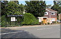
Image Map
Images are licensed for reuse under creativecommons.org/licenses/by-sa/2.0
Notes
- Clicking on the map will re-center to the selected point.
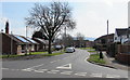
- The higher the marker number, the further away the image location is from the centre of the postcode.
Image Listing (30 Images Found)
Images are licensed for reuse under creativecommons.org/licenses/by-sa/2.0
Image
Details
Distance
1
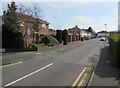
Rippledale Close, Cheltenham
Cul-de-sac extending for 100 metres from Hatherley Road.
Image: © Jaggery
Taken: 3 Apr 2016
0.09 miles
2
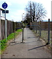
Combined footpath and cycleway, Hatherley, Cheltenham
Metal barriers prevent vehicular misuse of the path on the SE side of Hatherley Road.
The fence on the right is at the edge of this http://www.geograph.org.uk/photo/4892182 electricity substation.
Image: © Jaggery
Taken: 3 Apr 2016
0.11 miles
3
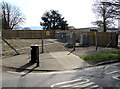
Hatherley Brake electricity substation, Cheltenham
The Western Power Distribution electricity substation is set back from Hatherley Road
near the Hatherley Lane junction. Its identifier is HATHERLEY BRAKE S/S 1121.
Image: © Jaggery
Taken: 3 Apr 2016
0.13 miles
4
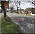
Warning sign - school, Hatherley Road, Cheltenham
On the approach to Lakeside Primary School.
Image: © Jaggery
Taken: 3 Apr 2016
0.13 miles
5
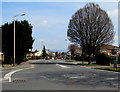
Faded mini-roundabout road markings, Hatherley, Cheltenham
At the Hatherley Road and Hatherley Lane junction, viewed in early April 2016.
No doubt many thousands of vehicles tyres have passed over the markings since they were last painted.
Image: © Jaggery
Taken: 3 Apr 2016
0.14 miles
6
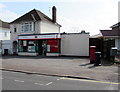
Brakeville, Up Hatherley, Cheltenham
The distinctive house at 267 Hatherley Road used to be a post office.
Image: © Jaggery
Taken: 3 Apr 2016
0.14 miles
7
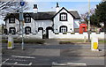
Up Hatherley Post Office, Cheltenham
At 238 Hatherley Road in the Up Hatherley area of Cheltenham.
Image: © Jaggery
Taken: 3 Apr 2016
0.14 miles
8
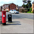
Queen Elizabeth II pillarbox outside Up Hatherley Post Office, Cheltenham
Located here. http://www.geograph.org.uk/photo/4892300
Image: © Jaggery
Taken: 3 Apr 2016
0.14 miles
9
Hatherley Road bus stop and shelter, Cheltenham
Opposite Rippledale Close. www.geograph.org.uk/photo/4892273
Image: © Jaggery
Taken: 3 Apr 2016
0.14 miles
10
Windermere Road, Hatherley, Cheltenham
Viewed across Hatherley Road. Windermere Road extends for 500 metres to Alma Road. Side roads connecting with Windermere Road also have Lake District names such as Grasmere Road, Coniston Road and Ullswater Road.
Image: © Jaggery
Taken: 3 Apr 2016
0.14 miles