IMAGES TAKEN NEAR TO
Dunalley Parade, CHELTENHAM, GL50 4LX
Introduction
This page details the photographs taken nearby to Dunalley Parade, GL50 4LX by members of the Geograph project.
The Geograph project started in 2005 with the aim of publishing, organising and preserving representative images for every square kilometre of Great Britain, Ireland and the Isle of Man.

There are currently over 7.5m images from over14,400 individuals and you can help contribute to the project by visiting https://www.geograph.org.uk
Image Map
Images are licensed for reuse under creativecommons.org/licenses/by-sa/2.0
Notes
- Clicking on the map will re-center to the selected point.
- The higher the marker number, the further away the image location is from the centre of the postcode.
Image Listing (126 Images Found)
Images are licensed for reuse under creativecommons.org/licenses/by-sa/2.0
Image
Details
Distance
1
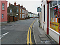
Marle Hill Parade, Cheltenham
At the right is a Chinese takeaway. Marle Hill Parade leads away from the viewpoint.
Image: © Brian Robert Marshall
Taken: 5 Nov 2009
0.04 miles
2
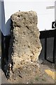
Stone block on the corner of Wellesley Road and Clarington Mews
The block obviously predates all the buildings around it. I cannot find anything explaining what it was part of and why it was left.
Image: © Terry Jacombs
Taken: 28 Mar 2012
0.06 miles
3
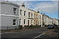
Georgian Houses
The houses here are Georgian, but much plainer than some of the better known streets of Cheltenham.
Image: © Anne Burgess
Taken: 7 Jul 2014
0.06 miles
4
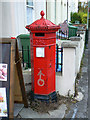
Penfold pillar box, St Paul's Road, Cheltenham
Here is one of the eight Penfold Victorian postboxes in the town. It looks rather neglected despite it being listed http://www.imagesofengland.org.uk/details/default.aspx?id=475899 It is situated outside a Chinese takeaway. It can be seen in its context here Image
Image: © Brian Robert Marshall
Taken: 5 Nov 2009
0.06 miles
5
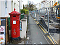
Penfold pillar box and St Paul's Road, Cheltenham
St Paul's Road is closed to traffic for the time being. Holes have been dug in it. At the left is the Victorian postbox seen in more detail here Image
Image: © Brian Robert Marshall
Taken: 5 Nov 2009
0.07 miles
6
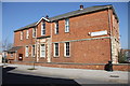
St Paul's Church Centre
The building was originally St Paul's School, which is still inscribed in stone over the middle lower window.
Image: © Terry Jacombs
Taken: 28 Mar 2012
0.08 miles
7
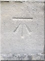
Ordnance Survey Cut Mark
This OS cut mark can be found on the SW angle of St Paul's Church. It marks a point 57.0417m above mean sea level.
Image: © Adrian Dust
Taken: 28 Jun 2015
0.08 miles
8
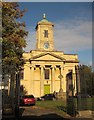
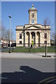
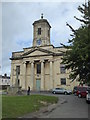
Church of St Paul, Cheltenham
"Built in a Greek Revival style, with details based on the Temple at Ilissus", Athens http://list.english-heritage.org.uk/resultsingle.aspx?uid=1387184&searchtype=mapsearch . "Constructed of pinkish-brown brick in English Garden Wall Bond, with ashlar facing to the west (actually south) front". This is indeed the south front, glowing in winter afternoon sun, and also shown in Image The church, seen here from across St Paul's Road, is listed grade II*. In front of it is a war memorial, also listed http://list.english-heritage.org.uk/resultsingle.aspx?uid=1419400&searchtype=mapsearch , as are the foreground railings and gates, contemporaneous with the church http://list.english-heritage.org.uk/resultsingle.aspx?uid=1387884&searchtype=mapsearch .
Image: © Derek Harper
Taken: 25 Oct 2014
0.08 miles