IMAGES TAKEN NEAR TO
Lypiatt Lane, CHELTENHAM, GL50 2JD
Introduction
This page details the photographs taken nearby to Lypiatt Lane, GL50 2JD by members of the Geograph project.
The Geograph project started in 2005 with the aim of publishing, organising and preserving representative images for every square kilometre of Great Britain, Ireland and the Isle of Man.

There are currently over 7.5m images from over14,400 individuals and you can help contribute to the project by visiting https://www.geograph.org.uk
Image Map
Images are licensed for reuse under creativecommons.org/licenses/by-sa/2.0
Notes
- Clicking on the map will re-center to the selected point.
- The higher the marker number, the further away the image location is from the centre of the postcode.
Image Listing (316 Images Found)
Images are licensed for reuse under creativecommons.org/licenses/by-sa/2.0
Image
Details
Distance
1
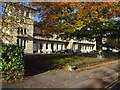
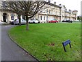
Lypiatt Terrace
A terrace of 17 houses with attached balustrades throughout, built around 1847. The architect was Samuel W Daukes and the builder, Richard Keitley. The Building is Grade II* listed, see: https://historicengland.org.uk/listing/the-list/list-entry/1245263
Image: © Philip Halling
Taken: 6 Nov 2018
0.01 miles
2
Lyppiatt Terrace
A terrace of 17 houses with attached balustrades throughout, built around 1847. The architect was Samuel W Daukes and the builder, Richard Keitley. The Building is Grade II* listed, see: https://historicengland.org.uk/listing/the-list/list-entry/1245263
Image: © Philip Halling
Taken: 19 Nov 2019
0.02 miles
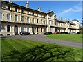
3
Lypiatt Terrace
A terrace of 17 houses with attached balustrades throughout, built around 1847. The architect was Samuel W Daukes and the builder, Richard Keitley. The Building is Grade II* listed, see: https://historicengland.org.uk/listing/the-list/list-entry/1245263
Image: © Philip Halling
Taken: 6 Nov 2018
0.02 miles
4
Lyppiatt Terrace
A terrace of 17 houses with attached balustrades throughout, built around 1847. The architect was Samuel W Daukes and the builder, Richard Keitley. The Building is Grade II* listed, see: https://historicengland.org.uk/listing/the-list/list-entry/1245263
Image: © Philip Halling
Taken: 6 Nov 2018
0.02 miles
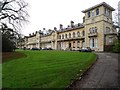
5
Parmoor House, Cheltenham
Parmoor House on Lyppiat Road in Cheltenham.
Image: © Philip Halling
Taken: 9 Jan 2016
0.03 miles
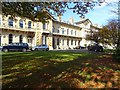
6
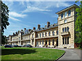
Lypiatt Terrace, Lypiatt Road, Cheltenham
A very fine terrace by Samuel Daukes, c1847, and not in Cheltenham's normal run of things. The long front is broken up by higher projecting sections. Round-arched windows abound. Grade II* listed.
Image: © Stephen Richards
Taken: 21 May 2015
0.03 miles
7
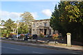
Victory Club - Lyppiat Road
A building with many names started life as Suffolk Hall and at one time was a boys school, Great War auxiliary hospital and now a jazz club.
Image: © John M
Taken: 12 Oct 2017
0.05 miles
8

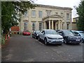
Burlington House, Lypiatt Road, Cheltenham
A large refined house featuring a Greek Doric porte-cochere. One of a sequence of villas on the street's east side built c1830, probably by Edward Jenkins. Grade II listed.
Like the others it has been converted into offices.
Image: © Stephen Richards
Taken: 21 May 2015
0.05 miles
9
Burlington House
Burlington House was formerly Suffolk Lawn and during the second half of the 19th century was Suffolk Hall Preparatory School. Oriana Souper who married Edward Wilson of Scott's ill-fated South Pole expedition was a matron here for a short time. During War World I the building was used as a Voluntary Aid Detachment. In the 1830s, the house was home to the actress Harriet Mellon, first wife of the 9th Duke of St Albans. Today the building is offices.
Image: © Philip Halling
Taken: 19 Nov 2019
0.05 miles
10
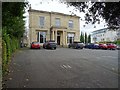
Carrick House
Carrick House on Lyppiat Road was built in the 1830s, today this Grade II is offices.
Image: © Philip Halling
Taken: 19 Nov 2019
0.05 miles