IMAGES TAKEN NEAR TO
Cranham, GLOUCESTER, GL4 8JA
Introduction
This page details the photographs taken nearby to GL4 8JA by members of the Geograph project.
The Geograph project started in 2005 with the aim of publishing, organising and preserving representative images for every square kilometre of Great Britain, Ireland and the Isle of Man.

There are currently over 7.5m images from over14,400 individuals and you can help contribute to the project by visiting https://www.geograph.org.uk
Image Map
Images are licensed for reuse under creativecommons.org/licenses/by-sa/2.0
Notes
- Clicking on the map will re-center to the selected point.
- The higher the marker number, the further away the image location is from the centre of the postcode.
Image Listing (20 Images Found)
Images are licensed for reuse under creativecommons.org/licenses/by-sa/2.0
Image
Details
Distance
2
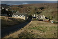
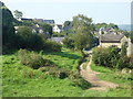
Cranham viewed from the east
Part of the village of Cranham viewed from the Common to the east of the village. Buckholt Wood can be seen in the background.
Image: © Philip Halling
Taken: 26 Jan 2008
0.15 miles
3
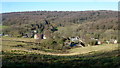
Cranham Common
Nestled in the valley with Buckholt Wood beyond.
Image: © Jonathan Billinger
Taken: 11 Feb 2016
0.15 miles
4
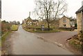
Junction, Cranham
Not just any junction; this point at the eastern edge of the villages is where the telephone box and bus stop are situated. The corner of the village hall, formerly a chapel and a pottery, is on the extreme right. Up the hill past the signpost is Cranham Common.
Image: © Derek Harper
Taken: 31 Dec 2010
0.17 miles
6
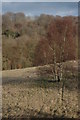
Silver Birch on Cranham Common
Silver birch tree on Cranham Common viewed from the road above the village. Buckholt Wood can be seen in the background.
Image: © Philip Halling
Taken: 26 Jan 2008
0.18 miles
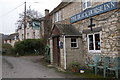
8
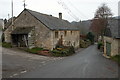
A lane in Cranham
Further on and just round the corner, on the right, and out of sight, is the Black Horse pub. The building which can be seen in the distance is Midwinter Cottage.
Image: © P L Chadwick
Taken: 6 Mar 2011
0.18 miles
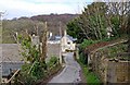
9
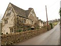
Village street, Cranham
On the left is The Old House, dating from the late C17 and early C18. The listed building description at http://www.britishlistedbuildings.co.uk/en-132711-the-old-house-cranham makes use of the word "off-centre" twice; there is a pleasing asymmetry about the design. Further up the road is the junction shown in Image
Image: © Derek Harper
Taken: 31 Dec 2010
0.20 miles
10
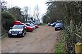
Car park, Cranham
This car park is used by customers of the nearby Black Horse pub, and probably by others too. You can continue to the end of the car park, where a track can be followed, which is one of the routes to the school and the church. There are some nice views en route too.
Image: © P L Chadwick
Taken: 6 Mar 2011
0.20 miles