IMAGES TAKEN NEAR TO
Cranham, GLOUCESTER, GL4 8HY
Introduction
This page details the photographs taken nearby to GL4 8HY by members of the Geograph project.
The Geograph project started in 2005 with the aim of publishing, organising and preserving representative images for every square kilometre of Great Britain, Ireland and the Isle of Man.

There are currently over 7.5m images from over14,400 individuals and you can help contribute to the project by visiting https://www.geograph.org.uk
Image Map
Images are licensed for reuse under creativecommons.org/licenses/by-sa/2.0
Notes
- Clicking on the map will re-center to the selected point.
- The higher the marker number, the further away the image location is from the centre of the postcode.
Image Listing (14 Images Found)
Images are licensed for reuse under creativecommons.org/licenses/by-sa/2.0
Image
Details
Distance
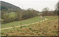
1
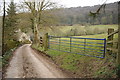
Track near Woodlands Farm, Cranham
Track and bridleway near Woodlands Farm, Cranham. The wooded Saltridge Hill is in the background.
Image: © Philip Halling
Taken: 23 Feb 2013
0.02 miles
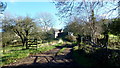
2

Gladys? Leap
The story of postwoman Gladys Hillier, who usually had to jump across this stream during her thirty-five years (1942-1977) of delivering mail since the plank was either dislodged, slippery or absent, inspired the title of Fairport Convention's 1985 album. The crossing was officially named by the Ordnance Survey in 1977, but this bridge didn't appear until 2005, when Gladys, then aged 88, was invited to open it. The footpath is MCR/27/2.
Image: © Derek Harper
Taken: 31 Dec 2010
0.09 miles
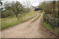
3
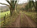
Track to Woodlands Farm
From the point where it is joined by footpath MCR/27/2. The track leads to the farm and the house seen in Image
Image: © Derek Harper
Taken: 31 Dec 2010
0.10 miles
4
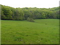
Saltridge Common Woods from the north west
Presumably the walker knew where he was going - there is no footpath shown on any maps I have.
Image: © Terry Jacombs
Taken: 18 May 2012
0.14 miles
5
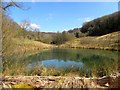
Pond near Brook Farm
This pond does not appear on the OS map so must be relatively new!
Image: © Colin Bews
Taken: 6 Apr 2013
0.15 miles
6
Path near Cranham
Footpath MCR/27 follows this stretch of track above a tributary of the Painswick Stream, but then leaves it at the furthest visible bend to drop and cross the stream at Gladys' Leap. On the left is Woodlands.
Image: © Derek Harper
Taken: 31 Dec 2010
0.15 miles
7
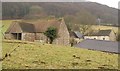
Batch Farm
Smoke rises from the farmhouse, tucked away behind barns in this view from bridleway MCR/26/3. Behind is Saltridge Wood.
Image: © Derek Harper
Taken: 31 Dec 2010
0.17 miles
8

Batch Farm
Image: © Derek Harper
Taken: 31 Dec 2010
0.19 miles
9
Batch Farm, near Cranham
Entrance road to Batch Farm.
Image: © Philip Halling
Taken: 23 Feb 2013
0.20 miles
10
Batch Farm, 2016
Image: © Jonathan Billinger
Taken: 11 Feb 2016
0.21 miles