IMAGES TAKEN NEAR TO
Upton Hill, GLOUCESTER, GL4 8DF
Introduction
This page details the photographs taken nearby to Upton Hill, GL4 8DF by members of the Geograph project.
The Geograph project started in 2005 with the aim of publishing, organising and preserving representative images for every square kilometre of Great Britain, Ireland and the Isle of Man.

There are currently over 7.5m images from over14,400 individuals and you can help contribute to the project by visiting https://www.geograph.org.uk
Image Map
Images are licensed for reuse under creativecommons.org/licenses/by-sa/2.0
Notes
- Clicking on the map will re-center to the selected point.
- The higher the marker number, the further away the image location is from the centre of the postcode.
Image Listing (4 Images Found)
Images are licensed for reuse under creativecommons.org/licenses/by-sa/2.0
Image
Details
Distance
1
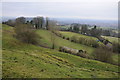
View from Cud Hill Common
View over Gloucester on a dull winter's day from Cud Hill Common.
Image: © Philip Halling
Taken: 5 Jan 2013
0.21 miles
2
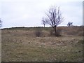
Spoonbed Hill
Looking south up the hill over unfenced probably common land.
Image: © Bob Embleton
Taken: 16 Mar 2006
0.21 miles
3
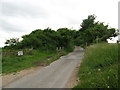
To stop them wandering - Painswick, Gloucestershire
On this stretch of unfenced road, running beside Spoonbed Hill and Cud Hill to the north of Painswick, an example of one method of controlling the movements of livestock, for their own safety and that of road users. Time taken 5.44 pm BST (British Summer Time).
Image Image
Image: © Martin Richard Phelan
Taken: 23 Jun 2013
0.24 miles
4
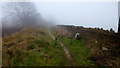
The Wysis Way, east
A cold misty day on the edge of the Cotswolds below Spoonbed Hill.
Image: © Jonathan Billinger
Taken: 30 Jan 2014
0.24 miles