1
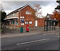
Upton St Leonards Post Office
Viewed across Churchfield Road from the corner of Six Acres. The post office inside the village shop in the background. The shop nearer the camera is The Clothes Press.
Image: © Jaggery
Taken: 22 Nov 2013
0.07 miles
2
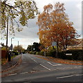
The Ash Path, Upton St Leonards
Viewed across Churchfield Road. The Ash Path is a residential street
leading to the city of Gloucester via a bridge over the M5 motorway.
Image: © Jaggery
Taken: 22 Nov 2013
0.10 miles
3
Upton St Leonards: Churchfield Road
Image: © Alby
Taken: 23 Mar 2008
0.10 miles
4
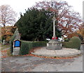
Upton St Leonards War Memorial
Located at the edge of Churchfield Road, near the entrance to St Leonard's Church.
The memorial, dedicated to the men of the village and surrounding area who were killed in the Great War, was unveiled and dedicated in August 1920, after a service in the church.
The Great War is now usually referred to as the First World War.
Image: © Jaggery
Taken: 22 Nov 2013
0.11 miles
5
Upton St Leonards sign
A plaque below this village sign in Upton St Leonards says that it was provided by USCAN in 1994.
Image: © Philip Halling
Taken: 2 Jan 2011
0.11 miles
6
Sundial, Upton St Leonards
This sundial is near the entrance to St Leonards church.
Image: © Philip Halling
Taken: 2 Jan 2011
0.11 miles
7
War Memorial, Upton St Leonards
Upton St Leonards' war memorial is situated near the main entrance to the church.
Image: © Philip Halling
Taken: 2 Jan 2011
0.12 miles
8
SW corner of the Memorial Gardens, Upton St Leonards
On the corner of Churchfield Road (on the left) and Bondend Road.
Image: © Jaggery
Taken: 22 Nov 2013
0.12 miles
9
Upton St. Leonards
A dormitory village on the southern outskirts of Gloucester.
Image: © Jonathan Billinger
Taken: 12 Aug 2013
0.12 miles
10
Entrance path to St Leonards Church, Upton St Leonards
From Churchfield Road. The War Memorial http://www.geograph.org.uk/photo/3760470 is just out of shot on the right.
Image: © Jaggery
Taken: 22 Nov 2013
0.12 miles


