IMAGES TAKEN NEAR TO
Oldway, GLOUCESTER, GL4 8AF
Introduction
This page details the photographs taken nearby to Oldway, GL4 8AF by members of the Geograph project.
The Geograph project started in 2005 with the aim of publishing, organising and preserving representative images for every square kilometre of Great Britain, Ireland and the Isle of Man.

There are currently over 7.5m images from over14,400 individuals and you can help contribute to the project by visiting https://www.geograph.org.uk
Image Map
Images are licensed for reuse under creativecommons.org/licenses/by-sa/2.0
Notes
- Clicking on the map will re-center to the selected point.
- The higher the marker number, the further away the image location is from the centre of the postcode.
Image Listing (49 Images Found)
Images are licensed for reuse under creativecommons.org/licenses/by-sa/2.0
Image
Details
Distance
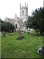
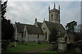
2
St Leonards Church
Grade II* listed parish church dating from the 13th century
Image: © Graham Hogg
Taken: 25 Apr 2016
0.04 miles
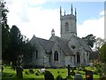
3
St Leonard's Church, Upton St Leonards
An almost identical view to Image, but it is the most striking.
Image: © Derek Harper
Taken: 4 Jul 2008
0.04 miles
4
St Leonard's Church, Upton St Leonards, nr Gloucester
Image: © Robert Rimell
Taken: 21 Mar 2011
0.04 miles
5
Upton St Leonards church
Upton St Leonards church is dedicated to St Leonard.
Image: © Philip Halling
Taken: 2 Jan 2011
0.04 miles
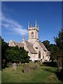
6
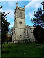
15th century church tower, Upton St Leonards
The tower of the Church of St Leonard was added
in the 15th century to the original late 13th century church.
Image: © Jaggery
Taken: 22 Nov 2013
0.05 miles
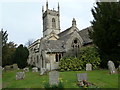
7
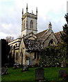
Church of St Leonard, Upton St Leonards
The church dates from the late 13th century, though little from that time survives.
The tower was added in the 15th century. There were various enlargements in the 19th century.
Image: © Jaggery
Taken: 22 Nov 2013
0.05 miles
8

Entrance to Upton St Leonards recreation ground
Viewed from Birchall Lane looking towards Upton St Leonards Pavilion.
Image: © Jaggery
Taken: 22 Nov 2013
0.05 miles
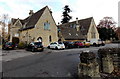
9
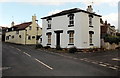
Rance Pitch houses, Upton St Leonards
Viewed from Birchall Lane. The houses are on the south side of Rance Pitch.
The High Street junction is in the lower right corner of the view.
Image: © Jaggery
Taken: 22 Nov 2013
0.06 miles
10
Chipmunks Day Nursery, Upton St Leonards
Located in the Grade II listed former Church of England primary school, built in 1850.
Image: © Jaggery
Taken: 22 Nov 2013
0.06 miles