IMAGES TAKEN NEAR TO
Corncroft Lane, GLOUCESTER, GL4 6XU
Introduction
This page details the photographs taken nearby to Corncroft Lane, GL4 6XU by members of the Geograph project.
The Geograph project started in 2005 with the aim of publishing, organising and preserving representative images for every square kilometre of Great Britain, Ireland and the Isle of Man.

There are currently over 7.5m images from over14,400 individuals and you can help contribute to the project by visiting https://www.geograph.org.uk
Image Map
Images are licensed for reuse under creativecommons.org/licenses/by-sa/2.0
Notes
- Clicking on the map will re-center to the selected point.
- The higher the marker number, the further away the image location is from the centre of the postcode.
Image Listing (20 Images Found)
Images are licensed for reuse under creativecommons.org/licenses/by-sa/2.0
Image
Details
Distance
1
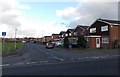
Haycroft Drive, Gloucester
Viewed across Corncroft Lane in the Matson district in the SE of Gloucester.
Image: © Jaggery
Taken: 22 Nov 2013
0.08 miles
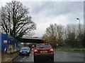
2
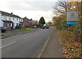
Welcome to the City of Gloucester
The B4073 leaves Upton St Leonards in Stroud District and enters Gloucester at its SE edge.
Image: © Jaggery
Taken: 22 Nov 2013
0.09 miles
3
From Winnycroft Lane to Corncroft Lane, Matson, Gloucester
Adjacent lane name signs in the south of Gloucester.
Image: © Jaggery
Taken: 22 Nov 2013
0.12 miles
4
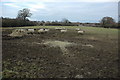
Sheep near Winnycroft Farm
Sheep near Winnycroft Farm on the edge of the suburbs of Gloucester at Matson.
Image: © Philip Halling
Taken: 2 Jan 2011
0.12 miles
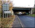
5
Upton St Leonards and Stroud District boundary sign
Viewed along the B4073 looking towards the bridge carrying the M5 motorway.
The City of Gloucester is on this side. The sign marks both a village boundary and district boundary.
Image: © Jaggery
Taken: 22 Nov 2013
0.13 miles
6
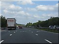
M5 Motorway approaching Upton St Leonards
Image: © J Whatley
Taken: 31 Aug 2010
0.14 miles
7
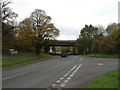
Upton St Leonards, motorway bridge
Taking M5 over Painswick Road.
Image: © Mike Faherty
Taken: 31 Oct 2010
0.16 miles
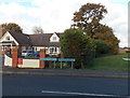
8
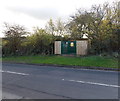
Winnycroft Lane electricity substation, Matson, Gloucester
Located on the south side of Winnycroft Lane near the Birchall Avenue junction.
Image: © Jaggery
Taken: 22 Nov 2013
0.16 miles
10
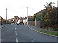
Birchall Avenue, Matson, Gloucester
Viewed from the Winnycroft Lane end.
Image: © Jaggery
Taken: 22 Nov 2013
0.17 miles