IMAGES TAKEN NEAR TO
Buttercup Lawn, GLOUCESTER, GL4 5XR
Introduction
This page details the photographs taken nearby to Buttercup Lawn, GL4 5XR by members of the Geograph project.
The Geograph project started in 2005 with the aim of publishing, organising and preserving representative images for every square kilometre of Great Britain, Ireland and the Isle of Man.

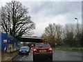
There are currently over 7.5m images from over14,400 individuals and you can help contribute to the project by visiting https://www.geograph.org.uk
Image Map
Images are licensed for reuse under creativecommons.org/licenses/by-sa/2.0
Notes
- Clicking on the map will re-center to the selected point.
- The higher the marker number, the further away the image location is from the centre of the postcode.
Image Listing (40 Images Found)
Images are licensed for reuse under creativecommons.org/licenses/by-sa/2.0
Image
Details
Distance
1
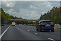
Stroud District : M5 Motorway
The M5 Motorway between Junction 12 and Junction 11A (Brockworth Interchange).
Image: © Lewis Clarke
Taken: 30 Sep 2018
0.07 miles
2
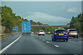
Upton St Leonards : M5 Motorway
The M5 Motorway between Junction 12 and Junction 11A (Brockworth Interchange).
Image: © Lewis Clarke
Taken: 22 Sep 2019
0.09 miles
3
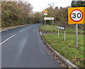
Welcome to the City of Gloucester
The B4073 leaves Upton St Leonards in Stroud District and enters Gloucester at its SE edge.
Image: © Jaggery
Taken: 22 Nov 2013
0.14 miles
4
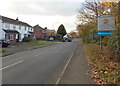
Upton St Leonards and Stroud District boundary sign
Viewed along the B4073 looking towards the bridge carrying the M5 motorway.
The City of Gloucester is on this side. The sign marks both a village boundary and district boundary.
Image: © Jaggery
Taken: 22 Nov 2013
0.16 miles
5
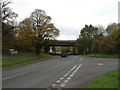
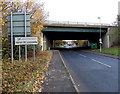
Upton St Leonards, motorway bridge
Taking M5 over Painswick Road.
Image: © Mike Faherty
Taken: 31 Oct 2010
0.17 miles
6
Birchall Lane, Upton St Leonards
Looking along Birchall Lane from Upton Hill towards the centre of the village.
Image: © Jaggery
Taken: 22 Nov 2013
0.18 miles
7
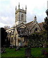
Church of St Leonard, Upton St Leonards
The church dates from the late 13th century, though little from that time survives.
The tower was added in the 15th century. There were various enlargements in the 19th century.
Image: © Jaggery
Taken: 22 Nov 2013
0.18 miles
8
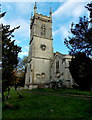
15th century church tower, Upton St Leonards
The tower of the Church of St Leonard was added
in the 15th century to the original late 13th century church.
Image: © Jaggery
Taken: 22 Nov 2013
0.18 miles
10

Entrance to Upton St Leonards recreation ground
Viewed from Birchall Lane looking towards Upton St Leonards Pavilion.
Image: © Jaggery
Taken: 22 Nov 2013
0.19 miles