IMAGES TAKEN NEAR TO
Peacock Close, GLOUCESTER, GL4 5EE
Introduction
This page details the photographs taken nearby to Peacock Close, GL4 5EE by members of the Geograph project.
The Geograph project started in 2005 with the aim of publishing, organising and preserving representative images for every square kilometre of Great Britain, Ireland and the Isle of Man.

There are currently over 7.5m images from over14,400 individuals and you can help contribute to the project by visiting https://www.geograph.org.uk
Image Map
Images are licensed for reuse under creativecommons.org/licenses/by-sa/2.0
Notes
- Clicking on the map will re-center to the selected point.
- The higher the marker number, the further away the image location is from the centre of the postcode.
Image Listing (12 Images Found)
Images are licensed for reuse under creativecommons.org/licenses/by-sa/2.0
Image
Details
Distance
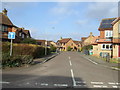
3
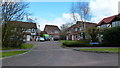
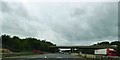
Gloucester, Abbeymead: Abbeymead Road
Abbeymead Road, towards Abbeydale
Image: © Alby
Taken: 24 Jan 2009
0.18 miles
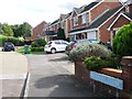
5
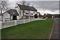
Blackberry Close, Hucclecote Green
1980's suburb of Gloucester.
Image: © Jonathan Billinger
Taken: 30 Mar 2013
0.19 miles
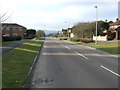
6
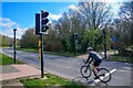
Gloucester : Matson - Abbeymead Avenue
A crossing on Abbeymead Avenue.
Image: © Lewis Clarke
Taken: 2 Apr 2023
0.20 miles
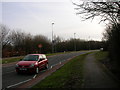
8
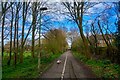
Gloucester : Matson - Footpath
A footpath heading towards Abbeymead Avenue.
Image: © Lewis Clarke
Taken: 2 Apr 2023
0.23 miles
10
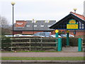
The Turmut Hoer, Abbeydale
This pub has had a revamp since it was last photographed for Geograph.
Image: © Philip Halling
Taken: 26 Feb 2011
0.24 miles