IMAGES TAKEN NEAR TO
Redstart Way, GLOUCESTER, GL4 4TJ
Introduction
This page details the photographs taken nearby to Redstart Way, GL4 4TJ by members of the Geograph project.
The Geograph project started in 2005 with the aim of publishing, organising and preserving representative images for every square kilometre of Great Britain, Ireland and the Isle of Man.

There are currently over 7.5m images from over14,400 individuals and you can help contribute to the project by visiting https://www.geograph.org.uk
Image Map
Images are licensed for reuse under creativecommons.org/licenses/by-sa/2.0
Notes
- Clicking on the map will re-center to the selected point.
- The higher the marker number, the further away the image location is from the centre of the postcode.
Image Listing (18 Images Found)
Images are licensed for reuse under creativecommons.org/licenses/by-sa/2.0
Image
Details
Distance
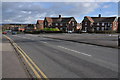
1
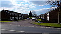
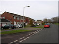
Redstart Way, Saintbridge, Gloucester
1970's suburbia.
Image: © Jonathan Billinger
Taken: 30 Mar 2013
0.00 miles
2
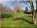
The diminutive River Twyver
A small area of green space in the Gloucester's suburb of Saintbridge.
Image: © Jonathan Billinger
Taken: 30 Mar 2013
0.05 miles
3
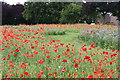
Poppy Field
Poppies planted at the junction of Bittern Avenue and Hawthorn Avenue, Abbeydale, Gloucester.
Image: © Colin Manton
Taken: 5 Jul 2014
0.06 miles
4
Footpath Redpoll Way to Cheyney Close, Gloucester
Taken after the floods of July 2007.
Image: © Colin Manton
Taken: 5 Aug 2007
0.11 miles
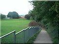
5
Footpath from Redpoll Way to Cheyney Close, Gloucester
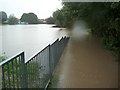
Taken during the flooding in July 2007. The flood waters covered an area larger than a football pitch to a depth of about 6 feet. It is assumed that the adjacent balancing pond and this area were created specifically to deal with a flood of this nature.
Image: © Colin Manton
Taken: 19 Jul 2007
0.14 miles
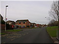
7
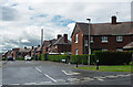
Hawthorn Avenue, Gloucester
Examples of a large council estate begun in 1931 by the City Architect, C.J. Scudamore.
Image: © Stephen Richards
Taken: 19 May 2015
0.15 miles
8
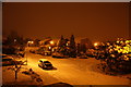
Oriole Way in the snow
Street Scene taken at 22:15hrs - Oriole Way, Abbeydale, Gloucester
Image: © Colin Manton
Taken: 21 Dec 2010
0.16 miles
10
Gloucester, Abbeydale: Bittern Avenue, Bus Stop
Image: © Alby
Taken: 24 Jan 2009
0.18 miles