IMAGES TAKEN NEAR TO
Curlew Road, GLOUCESTER, GL4 4TB
Introduction
This page details the photographs taken nearby to Curlew Road, GL4 4TB by members of the Geograph project.
The Geograph project started in 2005 with the aim of publishing, organising and preserving representative images for every square kilometre of Great Britain, Ireland and the Isle of Man.

There are currently over 7.5m images from over14,400 individuals and you can help contribute to the project by visiting https://www.geograph.org.uk
Image Map
Images are licensed for reuse under creativecommons.org/licenses/by-sa/2.0
Notes
- Clicking on the map will re-center to the selected point.
- The higher the marker number, the further away the image location is from the centre of the postcode.
Image Listing (14 Images Found)
Images are licensed for reuse under creativecommons.org/licenses/by-sa/2.0
Image
Details
Distance
1
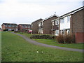
Curlew Road Gloucester
The houses in this part of town all face onto the wrong road, the address being the vehicle access at the back, very confusing for visitors and deliverymen.
Image: © Peter Watkins
Taken: 31 Jan 2006
0.07 miles

3
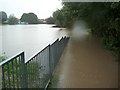
Footpath from Redpoll Way to Cheyney Close, Gloucester
Taken during the flooding in July 2007. The flood waters covered an area larger than a football pitch to a depth of about 6 feet. It is assumed that the adjacent balancing pond and this area were created specifically to deal with a flood of this nature.
Image: © Colin Manton
Taken: 19 Jul 2007
0.17 miles
4
Linnet Close, Gloucester
Viewed from the Heron Way end, near the corner of the B4073 Painswick Road.
Image: © Jaggery
Taken: 22 Nov 2013
0.18 miles
5

Saintbridge Sports Centre, Gloucester
Recently-built facility on the corner of Painswick Road and Norbury Avenue.
Image: © Jaggery
Taken: 22 Nov 2013
0.19 miles
6
Skylark Way, Gloucester
Viewed across the B4073 Painswick Road.
Image: © Jaggery
Taken: 22 Nov 2013
0.20 miles
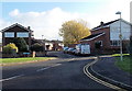
7

Roadworks at the edge of Matson North, Gloucester
Viewed across the B4073 Painswick Road in late November 2013 looking
towards Norbury Avenue and Saintbridge Sports Centre. http://www.geograph.org.uk/photo/3965690
Image: © Jaggery
Taken: 22 Nov 2013
0.20 miles
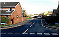
8
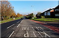
Keep Clear on Painswick Road, Gloucester
Looking NNW along the B4073 Painswick Road. The KEEP CLEAR is opposite Sudbrook Way.
Image: © Jaggery
Taken: 22 Nov 2013
0.21 miles
9
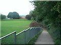
Footpath Redpoll Way to Cheyney Close, Gloucester
Taken after the floods of July 2007.
Image: © Colin Manton
Taken: 5 Aug 2007
0.22 miles
10
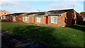
Painswick Road bungalows, Gloucester
The bungalows are near this http://www.geograph.org.uk/photo/3965769 Tesco Express, located on the opposite side of Painswick Road.
Image: © Jaggery
Taken: 22 Nov 2013
0.23 miles