IMAGES TAKEN NEAR TO
Cowley Road, GLOUCESTER, GL4 0HT
Introduction
This page details the photographs taken nearby to Cowley Road, GL4 0HT by members of the Geograph project.
The Geograph project started in 2005 with the aim of publishing, organising and preserving representative images for every square kilometre of Great Britain, Ireland and the Isle of Man.

There are currently over 7.5m images from over14,400 individuals and you can help contribute to the project by visiting https://www.geograph.org.uk
Image Map
Images are licensed for reuse under creativecommons.org/licenses/by-sa/2.0
Notes
- Clicking on the map will re-center to the selected point.
- The higher the marker number, the further away the image location is from the centre of the postcode.
Image Listing (4 Images Found)
Images are licensed for reuse under creativecommons.org/licenses/by-sa/2.0
Image
Details
Distance
1
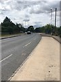
Stroud Road
This road (= the A4173) skirts the edge of Robin's Wood at this point.
Image: © HelenK
Taken: 29 Jul 2016
0.08 miles
2
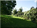
Open space between Holst Way and the railway
Image: © Jonathan Thacker
Taken: 3 Oct 2023
0.21 miles
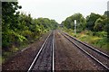
4

Social housing, Kemble Road
The Gloucester suburb of Tuffley with Robin's Wood Hill beyond.
Image: © Jonathan Billinger
Taken: 27 Dec 2012
0.24 miles