IMAGES TAKEN NEAR TO
Crickley Hill, GLOUCESTER, GL3 4UQ
Introduction
This page details the photographs taken nearby to Crickley Hill, GL3 4UQ by members of the Geograph project.
The Geograph project started in 2005 with the aim of publishing, organising and preserving representative images for every square kilometre of Great Britain, Ireland and the Isle of Man.

There are currently over 7.5m images from over14,400 individuals and you can help contribute to the project by visiting https://www.geograph.org.uk
Image Map
Images are licensed for reuse under creativecommons.org/licenses/by-sa/2.0
Notes
- Clicking on the map will re-center to the selected point.
- The higher the marker number, the further away the image location is from the centre of the postcode.
Image Listing (45 Images Found)
Images are licensed for reuse under creativecommons.org/licenses/by-sa/2.0
Image
Details
Distance
1
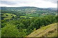
Wooded valley by Crickley Hill
The A417 runs through the trees below. You cannot see it but you can undoubtedly hear it.
Image: © Bill Boaden
Taken: 22 Jul 2015
0.04 miles
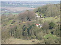
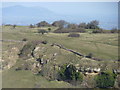
3
Crickley Hill, near Witcombe
High up on the left in amongst the trees is Crickley Hall. The hill in the background is Churchdown Hill over 6 kilometres away.
Image: © Brian Robert Marshall
Taken: 17 Oct 2007
0.09 miles
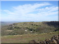
4
Crickley Hill Country Park (12)
This is a view east near the top of the Cotswold scarp. Next image http://www.geograph.org.uk/photo/1299629
Image: © Brian Robert Marshall
Taken: 11 May 2009
0.09 miles

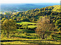
6

Crickley Hill Country Park (13)
The property at the lower left is named 'Clair-de-lune'. The settlement just beyond and to the left of the oilseed rape is Shurdington with beyond that the south-western outskirts of Cheltenham. The northern edge of the Malvern Hills is just visible at the extreme left of the horizon. Next image http://www.geograph.org.uk/photo/1300171
Image: © Brian Robert Marshall
Taken: 11 May 2009
0.10 miles
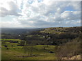
7
From Barrow Wake (3)
With the Malverns in the distance.
Image: © Jeff Gogarty
Taken: 10 Apr 2016
0.11 miles
8
From Barrow Wake(2)
Settlement at Devil's Table
Image: © Jeff Gogarty
Taken: 10 Apr 2016
0.11 miles
9
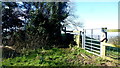
Locked footpath gate
Folks who want to walk the Gloucestershire Way will have to climb over this gate.
Possibly a defensive move by a farmer fed up with the gate being left open?
Image: © Jonathan Billinger
Taken: 11 Feb 2016
0.11 miles
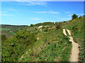
10
Crickley Hill from near The Peak
The Cotswold Way, day two 5:17pm
Image: © Ian S
Taken: 18 Apr 2013
0.11 miles