IMAGES TAKEN NEAR TO
Brockworth Road, GLOUCESTER, GL3 4RD
Introduction
This page details the photographs taken nearby to Brockworth Road, GL3 4RD by members of the Geograph project.
The Geograph project started in 2005 with the aim of publishing, organising and preserving representative images for every square kilometre of Great Britain, Ireland and the Isle of Man.

There are currently over 7.5m images from over14,400 individuals and you can help contribute to the project by visiting https://www.geograph.org.uk
Image Map
Images are licensed for reuse under creativecommons.org/licenses/by-sa/2.0
Notes
- Clicking on the map will re-center to the selected point.
- The higher the marker number, the further away the image location is from the centre of the postcode.
Image Listing (15 Images Found)
Images are licensed for reuse under creativecommons.org/licenses/by-sa/2.0
Image
Details
Distance
1
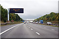
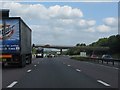
M5 southbound near Badgeworth
Towards Junction 11A
Image: © J.Hannan-Briggs
Taken: 22 Sep 2015
0.05 miles
3
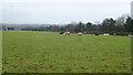
Pasture by the M5
You can't see the traffic from here (screened by the vegetation) but you can certainly hear it.
Image: © Jonathan Billinger
Taken: 24 Jan 2014
0.11 miles
5
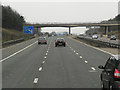
Approaching Cheltenham, M5 Northbound
The most obvious feature in the background is the GCHQ Headquarters (The Doughnut), not normally so visible in the Summer months when the trees form a more opaque barrier. The bridge in the foreground carries Brockworth Road.
Image: © Oliver Mills
Taken: 26 Dec 2021
0.15 miles
6
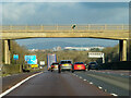
Brockworth Road bridge over M5
Older maps call the road "Green Street"
Image: © David Smith
Taken: 16 Oct 2012
0.16 miles
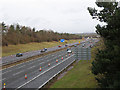
7
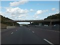
Churchdown : M5 Motorway
The M5 Motorway between 11A (Brockworth Interchange) and Junction 11 (Golden Valley Junction).
Image: © Lewis Clarke
Taken: 22 Sep 2019
0.16 miles
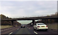
9
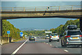
M5 Motorway - Brockworth Road bridge
The concrete blocks in the central reservation and around both side pillars are to provide extra protection against the risk of collision and consequent bridge collapse. This structure dates from the motorway's opening in 1971.
Image: © J Whatley
Taken: 31 Aug 2010
0.17 miles
10
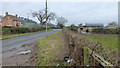
Woodfield farm
The farm buildings, along with this stretch of Brockworth Road is tucked into the south-west corner of the gridsquare.
Image: © Jonathan Billinger
Taken: 24 Jan 2014
0.19 miles