IMAGES TAKEN NEAR TO
The Green, GLOUCESTER, GL3 2LE
Introduction
This page details the photographs taken nearby to The Green, GL3 2LE by members of the Geograph project.
The Geograph project started in 2005 with the aim of publishing, organising and preserving representative images for every square kilometre of Great Britain, Ireland and the Isle of Man.

There are currently over 7.5m images from over14,400 individuals and you can help contribute to the project by visiting https://www.geograph.org.uk
Image Map
Images are licensed for reuse under creativecommons.org/licenses/by-sa/2.0
Notes
- Clicking on the map will re-center to the selected point.
- The higher the marker number, the further away the image location is from the centre of the postcode.
Image Listing (37 Images Found)
Images are licensed for reuse under creativecommons.org/licenses/by-sa/2.0
Image
Details
Distance
1
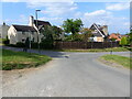
Road junction, Green Lane, Churchdown, Gloucester
The lane behind me leads up to Churchdown (also known as Chosen) Hill.
Image: © Ruth Sharville
Taken: 4 Sep 2021
0.03 miles
2
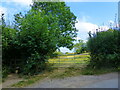
Stile to footpath, and field gate, Churchdown, Gloucester
Image: © Ruth Sharville
Taken: 4 Sep 2021
0.04 miles
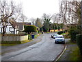
3
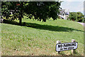
The Green, Churchdown
A pleasant area, east of Tinker's Hill, tucked between the A40 and the M5.
Image: © Pauline E
Taken: 3 Jul 2010
0.04 miles
4
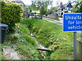
Stream at The Green, Churchdown, Gloucester
Image: © Ruth Sharville
Taken: 4 Sep 2021
0.05 miles
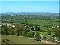
5
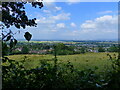
View from Churchdown (Chosen) Hill over Churchdown
Staverton Airfield (Gloucestershire Airport) can be made out in the far distance.
Image: © Ruth Sharville
Taken: 4 Sep 2021
0.07 miles
6
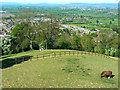
A view over Churchdown
Churchdown can be seen in the lee of its hill. In the far distance is Cheltenham with the Cotswolds on the horizon.
Image: © Brian Robert Marshall
Taken: 11 May 2009
0.13 miles
7
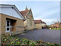
Churchdown Methodist church and hall
Set in quiet suburbia.
Image: © Jonathan Billinger
Taken: 18 Jan 2012
0.18 miles
8
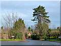
Payne's Pitch, Churchdown
Viewed from Drew's Court Road.
Image: © Jonathan Billinger
Taken: 18 Jan 2012
0.19 miles
9
Chapel Hay Lane
Churchdown is a quiet dormitory village for Gloucester and Cheltenham.
Image: © Jonathan Billinger
Taken: 18 Jan 2012
0.19 miles
10
The south-eastern edge of Churchdown
There are fine views from the churchyard of St Bartholomew's. The road leading away to the right of the image is Brockworth Road. It reaches the Gloucester suburb of that name after crossing the M5 and the A417.
Image: © Brian Robert Marshall
Taken: 11 May 2009
0.20 miles