IMAGES TAKEN NEAR TO
Whitehall Lane, GLOUCESTER, GL2 8ED
Introduction
This page details the photographs taken nearby to Whitehall Lane, GL2 8ED by members of the Geograph project.
The Geograph project started in 2005 with the aim of publishing, organising and preserving representative images for every square kilometre of Great Britain, Ireland and the Isle of Man.

There are currently over 7.5m images from over14,400 individuals and you can help contribute to the project by visiting https://www.geograph.org.uk
Image Map
Images are licensed for reuse under creativecommons.org/licenses/by-sa/2.0
Notes
- Clicking on the map will re-center to the selected point.
- The higher the marker number, the further away the image location is from the centre of the postcode.
Image Listing (8 Images Found)
Images are licensed for reuse under creativecommons.org/licenses/by-sa/2.0
Image
Details
Distance
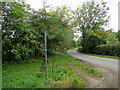
1
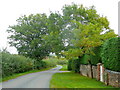
Whitehall Lane
Looking north-east towards Rudford and the B4215 Gloucester-Newent road.
Image: © Jonathan Billinger
Taken: 18 Oct 2010
0.04 miles
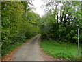
2
Whitehall Lane
Heading back to Rudford and the B4215.
Image: © Pauline E
Taken: 21 Aug 2008
0.07 miles
3
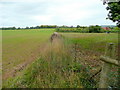
Footpath along the field edge
Heading north towards Rudford from Whitehall Lane.
Image: © Jonathan Billinger
Taken: 18 Oct 2010
0.10 miles
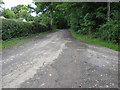
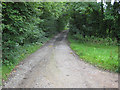
4
Whitehall Lane
A no-through road to Whitehall Farm.
Image: © Pauline E
Taken: 21 Aug 2008
0.13 miles
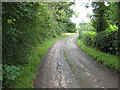
5
Bend in Whitehall Lane
A dead-end lane near Prior's Wood.
Image: © Jonathan Billinger
Taken: 18 Oct 2010
0.13 miles
6
Footpath into Prior's Wood
Leading south away from Whitehall Lane.
Image: © Jonathan Billinger
Taken: 18 Oct 2010
0.14 miles
8
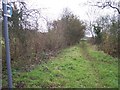
The Old Road to Bulley and Churcham
Now down graded to a mere bridleway. Looking SSW from the 90 degree bend in the no through road to Whitelands.
Image: © Bob Embleton
Taken: 14 Dec 2005
0.24 miles