IMAGES TAKEN NEAR TO
Henry Withers Place, GLOUCESTER, GL2 7LR
Introduction
This page details the photographs taken nearby to Henry Withers Place, GL2 7LR by members of the Geograph project.
The Geograph project started in 2005 with the aim of publishing, organising and preserving representative images for every square kilometre of Great Britain, Ireland and the Isle of Man.

There are currently over 7.5m images from over14,400 individuals and you can help contribute to the project by visiting https://www.geograph.org.uk
Image Map
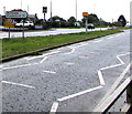
Images are licensed for reuse under creativecommons.org/licenses/by-sa/2.0
Notes
- Clicking on the map will re-center to the selected point.
- The higher the marker number, the further away the image location is from the centre of the postcode.
Image Listing (119 Images Found)
Images are licensed for reuse under creativecommons.org/licenses/by-sa/2.0
Image
Details
Distance
1
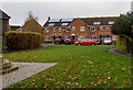
Cars and houses in The Close, Whitminster
An edge of Whitminster War Memorial https://www.geograph.org.uk/photo/6313195 is on the left.
Image: © Jaggery
Taken: 3 Nov 2019
0.01 miles
2
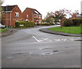
The Close, Whitminster
Viewed across School Lane. The Close leads to Vaisey Field and Paynes Meadow.
Image: © Jaggery
Taken: 3 Nov 2019
0.01 miles
3
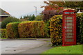
Red phonebox, The Close, Whitminster
On the right here. https://www.geograph.org.uk/photo/6316197
Image: © Jaggery
Taken: 3 Nov 2019
0.02 miles
4
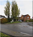
Junction of School Lane and The Close, Whitminster
Viewed across School Lane.
Image: © Jaggery
Taken: 3 Nov 2019
0.03 miles
5

Whitminster War Memorial
Located between the A38 Bristol Road and The Close (ahead).
Image: © Jaggery
Taken: 3 Nov 2019
0.03 miles
6
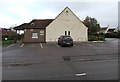
Whitminster Village Hall
Set back from School Lane near the Bristol Road junction in Whitminster, Gloucestershire.
Image: © Jaggery
Taken: 3 Nov 2019
0.03 miles
7
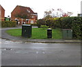
Two cabinets and a litter bin on a Whitminster corner
A litter bin is between two telecoms cabinets on the School Lane side of the corner of The Close.
Image: © Jaggery
Taken: 3 Nov 2019
0.03 miles
8
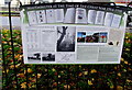
Historical information board near Whitminster War Memorial
The board is titled WHITMINSTER AT THE TIME OF THE GREAT WAR 1914-1918.
The Great War is now usually referred to as the First World War or World War I.
Whitminster War Memorial https://www.geograph.org.uk/photo/6313195 is behind the camera.
Image: © Jaggery
Taken: 3 Nov 2019
0.04 miles
9
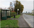
Bristol Road bus stop and shelter, Whitminster
This stop alongside the A38 is for buses to Gloucester.
Image: © Jaggery
Taken: 3 Nov 2019
0.04 miles
10
Whitminster and Wheatenhurst direction sign, Gloucestershire
On the grass strip in the middle of the dual carriageway A38 Bristol Road.
Turn right ahead for School Lane in Whitminster which leads to Wheatenhurst a mile and a half away.
Image: © Jaggery
Taken: 3 Nov 2019
0.04 miles