IMAGES TAKEN NEAR TO
Kingston Road, GLOUCESTER, GL2 7BW
Introduction
This page details the photographs taken nearby to Kingston Road, GL2 7BW by members of the Geograph project.
The Geograph project started in 2005 with the aim of publishing, organising and preserving representative images for every square kilometre of Great Britain, Ireland and the Isle of Man.

There are currently over 7.5m images from over14,400 individuals and you can help contribute to the project by visiting https://www.geograph.org.uk
Image Map
Images are licensed for reuse under creativecommons.org/licenses/by-sa/2.0
Notes
- Clicking on the map will re-center to the selected point.
- The higher the marker number, the further away the image location is from the centre of the postcode.
Image Listing (33 Images Found)
Images are licensed for reuse under creativecommons.org/licenses/by-sa/2.0
Image
Details
Distance
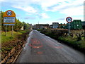
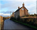
1
Stroud District : Kingston Road
A road heading alongside Kingston Farm.
Image: © Lewis Clarke
Taken: 25 Feb 2017
0.04 miles
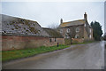
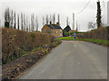
2
Grade II listed Kingston Farmhouse near Slimbridge
Located on Kingston Road beyond the northern boundary of Slimbridge village.
Dating from the mid 19th century, the farmhouse was Grade II listed in April 1984.
Image: © Jaggery
Taken: 18 Dec 2011
0.06 miles
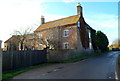
3

Cottage on Kingston Road
By the junction of Lightenbrook Lane.
Image: © Jonathan Thacker
Taken: 15 Sep 2015
0.08 miles
4
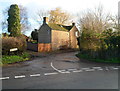
Lightenbrook Lane near Slimbridge
Lightenbrook Lane heads away from Kingston Road, past Kingston Cottage.
Image: © Jaggery
Taken: 18 Dec 2011
0.09 miles
5
NW boundary of Slimbridge village
Looking SE along Kingston Road. The Wildfowl and Wetlands Trust's Reserve Image is located about a kilometre behind the camera.
Image: © Jaggery
Taken: 18 Dec 2011
0.13 miles
6
Fairlawne near Slimbridge
Located on Kingston Road between the Wildfowl and Wetlands Trust's Reserve and the northern boundary of Slimbridge village.
Image: © Jaggery
Taken: 18 Dec 2011
0.14 miles

9
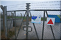
Stroud District : Water Substation
An area owned by Severn Trent Water.
Image: © Lewis Clarke
Taken: 25 Feb 2017
0.15 miles
10
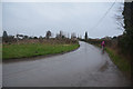
Stroud District : Kingston Road
A road heading away from Slimbridge.
Image: © Lewis Clarke
Taken: 25 Feb 2017
0.15 miles